Image:NE 800ad.jpg
From Wikipedia, the free encyclopedia
Size of this preview: 582 × 480 pixels
Full resolution (1,533 × 1,264 pixels, file size: 552 KB, MIME type: image/jpeg)
 |
This is a candidate to be copied to the Wikimedia Commons. Appropriately licensed media are more accessible to other Wikimedia projects if placed on Commons. Any user may perform this move - please see Moving images to the Commons for more information. Please remove this tag after this image has been copied to Commons. Copy to Commons via CommonsHelper |
| Description |
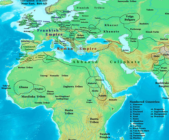
Europe, west Asia, and north Africa in 800 AD. |
|||
|---|---|---|---|---|
| Source |
Self-made (For reference information, see below) |
|||
| Date |
1-30-2008 |
|||
| Author |
Thomas Lessman ( Contact!) |
|||
| Permission ( Reusing this image) |
|
|||
| Other versions | see below |
Contents |
Map Info Summary

Original Source URL: http://www.thomaslessman.com/History/images/East-Hem_800ad.jpg.
This map is a zoomed-in version of the Eastern Hemisphere in 800 AD, created by Thomas Lessman. This map is free for educational use (see Permission info above). When using this map, please mention that it is available for free at www.WorldHistoryMaps.info.
The borders are based on information from the sources listed in the Map References section below.
Keep in mind that sources often conflict with each other, and they are only as accurate as the information that is available to the author. To report any errors, or if you want to help further this work, please see here, or email Thomas Lessman at talessman@yis.us.
Map References
References for information contained in this map:
See the map references for East-Hem_800ad.jpg
Other Historical Maps by Thomas Lessman
|
|||||||||||
Other Info
File history
Click on a date/time to view the file as it appeared at that time.
| Date/Time | Dimensions | User | Comment | |
|---|---|---|---|---|
| current | 23:49, 2 January 2008 | 1,533×1,264 (552 KB) | Talessman ( Talk | contribs) | (Corrected borders in Africa, added more info for Europe, Asia, and Africa, added numbered legend for smaller nations, etc.) |
| revert | 20:27, 31 October 2007 | 1,412×957 (403 KB) | Talessman ( Talk | contribs) | (Corrected borders of Ghana and made some names a little easier to read.) |
| revert | 23:54, 20 October 2007 | 1,245×778 (311 KB) | Talessman ( Talk | contribs) | (Author: Thomas A. Lessman. Source URL: http://www.ThomasLessman.com/History/images/East-Hem_800ad.jpg. Image was created by me (Thomas Lessman) based on map of Eastern Hemisphere in 500ad. Image is free for public and/or educational use. I would appreciat) |
See the setup instructions for more information.