Image:East-Hem 001ad.jpg
From Wikipedia, the free encyclopedia
Size of this preview: 640 × 376 pixels
Full resolution (3,240 × 1,903 pixels, file size: 709 KB, MIME type: image/jpeg)
| |
This is a file from the Wikimedia Commons. The description on its description page there is shown below. |
Contents |
Summary
 |
This map image should be recreated using vector graphics as an SVG file. This has several advantages; see Commons:Media for cleanup for more information. If an SVG form of this image is already available, please upload it. After uploading an SVG, replace this template with {{ vector version available|new image name.svg}}. |
|
العربية | Български | Català | Česky | Dansk | Deutsch | English | Esperanto | Español | Français | Galego | 한국어 | Italiano | Magyar | Lietuvių | Nederlands | 日本語 | Polski | Português | Română | Русский | Suomi | Svenska | Türkçe | Українська | 中文(繁體) | 中文(简体) | +/- |
|
| Description |
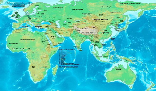
Eastern Hemisphere in 001 AD. |
|||
|---|---|---|---|---|
| Source |
self-made (For reference information, see the Map Source References section below.) |
|||
| Date | ||||
| Author |
Thomas Lessman ( Contact!) |
|||
| Permission ( Reusing this image) |
|
|||
| Other versions | see East-Hem_001ad.jpg file history on Wikipedia. |
Map Summary
Original Source URL: http://www.thomaslessman.com/History/images/East-Hem_001ad.jpg.
This map of the Eastern Hemisphere in 001 AD was created by Thomas Lessman, based on information from the sources listed below. This map is free for educational use (see Permission info above). When using this map, please mention that it is available for free at www.WorldHistoryMaps.info.
Map Source References
- Remember, sources often conflict with each other. This map is only as accurate as the information that is available to me. To report any errors or to help further this work, please click here, or email Thomas Lessman at talessman@yis.us
References for information contained in this map:
1. Borders of Europe are mostly derived from the www.Euratlas.com map of Europe in 001 AD.
2. Borders of Asian countries are derived primarily from these sources:
- a - The DK Atlas of World History, 2000 Edition; map of The World in 1 CE, (Pages 42-43) was used for information on several Asian borders in this map.
- b - WorldHistoryMaps.com map of the Countries of the World 1/1/36 bce provides some borders for India and other parts of Asia.
- c - Parthia's border with the Indo-Scythians and Tocharians is derived from Wikipedia articles about Kushan King Heraios, the Indo-Scythians, and the Kushan Empire.
- d - Kashmir/Chach is described in the Wikipedia article about Zeionises.
- b - WorldHistoryMaps.com map of the Countries of the World 1/1/36 bce provides some borders for India and other parts of Asia.
3. Some information also derives from Wikimedia's map of the World_1_CE, created by User:Javierfv1212.
4. Korean borders derive from this map of Korea_001.png made by Wikipedia User:Historiographer.
5. Much of the information in this map was cross-checked with Bruce Gordon's Regnal Chronologies.
Other Maps by Thomas Lessman
| World History Maps showing history of the World or Eastern Hemisphere. Bold dates are available on Wikimedia or Wikipedia. |
||
| Primeval |
·| 1300 BC | 1200 BC | 1000 BC | 700 BC | 625 BC | |
|
|
|
||
| Ancient BC / BCE
AD / CE |
·| 600 BC | 550 BC | 527 BC | 500 BC | 400 BC | ·| 001 AD | 050 AD | 100 AD | 200 AD | 300 AD | |
|
| Medieval |
·| 500 AD | 525 AD | 565 AD | 600 AD | 700 AD | |
|
| Modern |
·| 1500 AD | · * For more maps after 1500 AD (and before), |
|
Licensing
|
File history
Click on a date/time to view the file as it appeared at that time.
| Date/Time | Dimensions | User | Comment | |
|---|---|---|---|---|
| current | 06:45, 9 May 2008 | 3,240×1,903 (709 KB) | Talessman | ({{Information |Description='''Eastern Hemisphere in 001 AD'''. |Source=self-made (For reference information, see below) |Author= Thomas Lessman ( Contact!) |Date= |Location= |Permission={{self|cc-by-sa-3.0}} |other) |