Image:East-Hem 600ad.jpg
From Wikipedia, the free encyclopedia
Size of this preview: 640 × 376 pixels
Full resolution (3,240 × 1,903 pixels, file size: 783 KB, MIME type: image/jpeg)
| |
This is a file from the Wikimedia Commons. The description on its description page there is shown below. |
| Description |
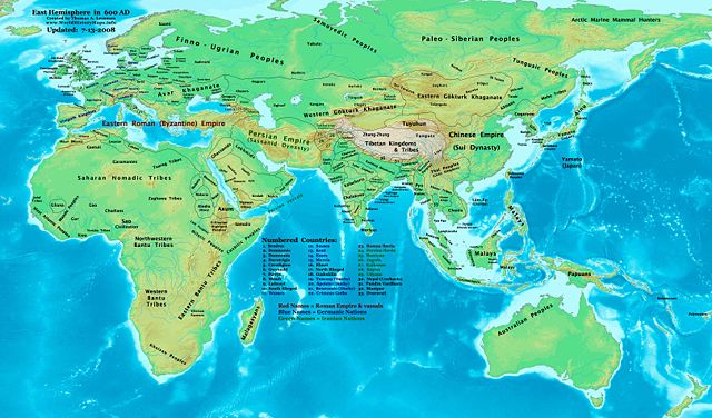
Eastern Hemisphere in 600 AD. |
|||
|---|---|---|---|---|
| Source |
self-made (For reference information, see the Map Source References section below.) |
|||
| Date | ||||
| Author |
Thomas Lessman ( Contact!) |
|||
| Permission ( Reusing this image) |
|
|||
| Other versions | see East-Hem_600ad.jpg file history on Wikipedia. |
Map Summary
Original Source URL: http://www.thomaslessman.com/History/images/East-Hem_600ad.jpg.
This map of the Eastern Hemisphere in 600 AD was created by Thomas Lessman, based on information from the sources listed below. This map is free for educational use (see Permission info above). When using this map, please mention that it is available for free at www.WorldHistoryMaps.info.
Map Source References
- Remember, sources often conflict with each other. This map is only as accurate as the information that is available to me. To report any errors or to help further this work, please click here, or email Thomas Lessman at talessman@yis.us
References for information contained in this map:
1. Borders of Europe are mostly derived from the www.Euratlas.com map of Europe in 600 AD.
- (Please note: User:Bogomolov.PL has done a great job of showing me possible discrepancies in my north European borders compared to this source, due to the differences in the geographical layout of the maps.)
2. Borders of Britain derived from " EarlyBritishKingdoms.com" map of Britain in 600 AD.
3. Borders of Asian countries are derived mostly from the Huhai.net map of Asia in 610 AD, as well as Wikipedia articles related to countries and peoples depicted in this map.
-
- Gokturk borders are derived from User:Briangotts' map of the Gokturk Khaganates, 600 CE.
- Borders of India are derived mainly from this map of the Pallava Empire, 550-600 AD.
4. Fringe areas like Africa, Australia, Siberia, etc. are partially derived from Wikimedia's map of The_world_in_500_CE, created by User:Javierfv1212.
5. Much of the information in this map was cross-checked with Bruce Gordon's Regnal Chronologies.
Other Maps by Thomas Lessman
| World History Maps showing history of the World or Eastern Hemisphere. Bold dates are available on Wikimedia or Wikipedia. |
||
| Primeval |
·| 1300 BC | 1200 BC | 1000 BC | 700 BC | 625 BC | |
|
|
|
||
| Ancient BC / BCE
AD / CE |
·| 600 BC | 550 BC | 527 BC | 500 BC | 400 BC | ·| 001 AD | 050 AD | 100 AD | 200 AD | 300 AD | |
|
| Medieval |
·| 500 AD | 525 AD | 565 AD | 600 AD | 700 AD | |
|
| Modern |
·| 1500 AD | · * For more maps after 1500 AD (and before), |
|
Original upload log
The original description page is/was here. All following user names refer to en.wikipedia.
- 2008-01-08 04:00 Talessman 3240×1903×8 (761768 bytes) Corrected borders in southeast Asia, Central Asia, and India. Also added more info to numbered legend.
- 2007-12-23 05:45 Talessman 3240×1903×8 (770859 bytes) Added numbered legend. Corrected borders of India, southeast Asia, and Korea. Added more information for Indonesia, Manchuria, central asia, and Africa.
- 2007-11-02 18:32 Talessman 3240×1903×8 (712068 bytes) Corrected borders of Makuria, Alodia, Blemmys, Nobatia, and Arab kingdoms.
- 2007-10-30 00:36 Talessman 3240×1903×8 (712926 bytes)
- 2007-10-26 22:38 Talessman 2880×1692×8 (569661 bytes) Reverted to version as of 16:09, 26 September 2007 (reverted to earlier full version due to uploading of new cropped versions of same image, to allow full version)
- 2007-10-19 18:08 Dbachmann 2412×1062×8 (641315 bytes) cropped
- 2007-09-26 16:09 Talessman 2880×1692×8 (569661 bytes) Author: Thomas A. Lessman. Source URL: http://www.ThomasLessman.com/History/images/East-Hem_600ad.jpg. Image was created by me (Thomas Lessman) based on historical information located on Wikipedia, as well as information from maps located in Wikipedia and
- 2007-09-12 21:34 Talessman 2880×1692×8 (557321 bytes) Author: Thomas A. Lessman. Source URL: http://www.ThomasLessman.com/History/images/East-Hem_600ad.jpg. Image was created by me (Thomas Lessman) based on historical information located on Wikipedia, as well as information from maps located in Wikipedia and
- 2007-07-21 20:35 Talessman 1973×1159×8 (2392834 bytes) Author: Thomas A. Lessman. Source URL: http://www.ThomasLessman.com/History/images/East-Hem_600ad.jpg. Image was created by me (Thomas Lessman) based on historical information located on Wikipedia, as well as information from maps located in Wikipedia and
File history
Click on a date/time to view the file as it appeared at that time.
| Date/Time | Dimensions | User | Comment | |
|---|---|---|---|---|
| current | 17:11, 15 July 2008 | 3,240×1,903 (783 KB) | Talessman | (Updates: Major corrections to Gokturk borders, India, and other areas. Other minor corrections.) |
| 18:33, 9 May 2008 | 3,240×1,903 (762 KB) | Talessman | ({{Information |Description=East Hem in 600 AD |Source=self-made |Author= Talessman |Permission={{self|cc-by-sa-3.0}} }} ) |