Image:East-Hem 100bc.jpg
From Wikipedia, the free encyclopedia
Size of this preview: 640 × 376 pixels
Full resolution (3,240 × 1,903 pixels, file size: 737 KB, MIME type: image/jpeg)
| |
This is a file from the Wikimedia Commons. The description on its description page there is shown below. |
 |
This map image should be recreated using vector graphics as an SVG file. This has several advantages; see Commons:Media for cleanup for more information. If an SVG form of this image is already available, please upload it. After uploading an SVG, replace this template with {{ vector version available|new image name.svg}}. |
|
العربية | Български | Català | Česky | Dansk | Deutsch | English | Esperanto | Español | Français | Galego | 한국어 | Italiano | Magyar | Lietuvių | Nederlands | 日本語 | Polski | Português | Română | Русский | Suomi | Svenska | Türkçe | Українська | 中文(繁體) | 中文(简体) | +/- |
|
| Description |
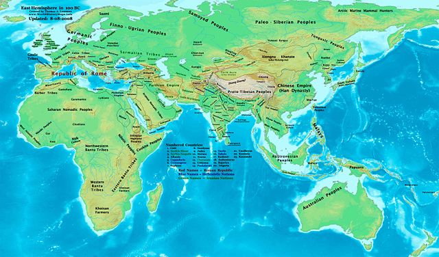
Eastern Hemisphere in 100 BC. |
|||
|---|---|---|---|---|
| Source |
self-made (For reference information, see below) |
|||
| Date | ||||
| Author |
Thomas Lessman ( Contact!) |
|||
| Permission ( Reusing this image) |
|
|||
| Other versions | see East-Hem_100bc.jpg file history on Wikipedia. |
Contents |
Map Summary
Original Source URL: http://www.thomaslessman.com/History/images/East-Hem_100bc.jpg.
This map of the Eastern Hemisphere in 100 BC was created by Thomas Lessman, based on information from the sources listed below. This map is free for educational use (see Permission info above). When using this map, please mention that it is available for free at www.WorldHistoryMaps.info.
Map Source References
(This section is being revised, please be patient!)
- Remember, sources often conflict with each other. This map is only as accurate as the information that is available to me. To report any errors or to help further this work, please click here, or email Thomas Lessman at talessman@yis.us
References for information contained in this map:
1. Borders of Europe are derived from:
- Roman Empire is well documented. Here are some of the better sources I used:
- * The DK Atlas of World History, 2000 Edition; map of Roman Conquests to 120 BC;(Page 179)
- * This map of the Phases of the Roman Empire by User:Varana.
- * The DK Atlas of World History, 2000 Edition; map of Roman Conquests to 120 BC;(Page 179)
2. Borders of Asia are derived from the following sources:
- Armenia borders derive from the map of the Armenian Empire, 95-66 BC under Tigranes the Great.
- Atropatene borders come from this map of the Armenian Empire, 95-66 BC under Tigranes the Great.
- Indo-Greek Kingdoms are derived from:
- * Wikimedia's map of the World_in_100_BCE.PNG by User:Javierfv1212.
- Judea borders are derived from:
- * Wikipedia's article on the Hasmonean Kingdom,
- * This map of the Armenian Empire, 95-66 BC under Tigranes the Great.
- * This map of Israeli Borders, 167-76 BC (available on Livius.org).
- Kashmir under the Saka King Maues, is described on the Iranica.com article about the Indo-Scythians
- Mahameghavahanas are shown in Wikimedia's map of the World_in_100_BCE.PNG by User:Javierfv1212.
- Palmyra borders are derived from Wikipedia's article about Palmyra, and from Wikimedia's map of the World_in_100_BCE.PNG by User:Javierfv1212.
- Parthian Empire borders are derived from
- Persia borders are shown in the WorldHistoryMaps.com map of the old world in 036 BC and their map of 150 BC.
- Pontus borders are derived from this map of the Armenian Empire, 95-66 BC under Tigranes the Great.
- Ptolemaic Kingdom
- Sakastan borders come from this map of Sakastan in 100 BC, available on Wikipedia's article on Sakastan.
- Satavahana Dynasty
- Seleucia borders are derived from this map of the Armenian Empire, 95-66 BC under Tigranes the Great.
- * Note: Seleucid rule over the "spur" of land west of Judea is derived from William R. Shepherd's map of The Growth of Roman Power in Asia (Asia Minor II).
- Sunga Dynasty
- Atropatene borders come from this map of the Armenian Empire, 95-66 BC under Tigranes the Great.
3. Fringe areas like Africa, Australia, Siberia, etc. are derived mostly from Wikimedia's map of the World_in_100_BCE.PNG by User:Javierfv1212.
4. Much of the information in this map was cross-checked with Bruce Gordon's Regnal Chronologies.
Other Maps by Thomas Lessman
| World History Maps showing history of the World or Eastern Hemisphere. Bold dates are available on Wikimedia or Wikipedia. |
||
| Primeval |
·| 1300 BC | 1200 BC | 1000 BC | 700 BC | 625 BC | |
|
|
|
||
| Ancient BC / BCE
AD / CE |
·| 600 BC | 550 BC | 527 BC | 500 BC | 400 BC | ·| 001 AD | 050 AD | 100 AD | 200 AD | 300 AD | |
|
| Medieval |
·| 500 AD | 525 AD | 565 AD | 600 AD | 700 AD | |
|
| Modern |
·| 1500 AD | · * For more maps after 1500 AD (and before), |
|
Other Information
Previous
File history
Click on a date/time to view the file as it appeared at that time.
| Date/Time | Dimensions | User | Comment | |
|---|---|---|---|---|
| current | 18:57, 9 August 2008 | 3,240×1,903 (737 KB) | Talessman | ({{Information |Description= |Source= |Date= |Author= |Permission= |other_versions= }}) |
| 06:33, 16 May 2008 | 3,240×1,903 (695 KB) | Talessman | (Corrected borders of Korea, India, and Parthia. Added more info for central Asia.) | |
| 15:02, 9 May 2008 | 3,240×1,903 (699 KB) | Talessman | ({{Information |Description='''Eastern Hemisphere in 100 BC'''. |Source=self-made |Author= Thomas Lessman |Permission={{self|cc-by-sa-3.0}} }}) |