Image:East-Hem 700ad.jpg
From Wikipedia, the free encyclopedia
Size of this preview: 640 × 376 pixels
Full resolution (3,240 × 1,903 pixels, file size: 924 KB, MIME type: image/jpeg)
| |
This is a file from the Wikimedia Commons. The description on its description page there is shown below. |
| Description |
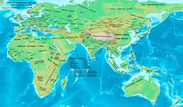
Eastern Hemisphere in 700 AD. |
|||
|---|---|---|---|---|
| Source |
self-made (For reference information, see the Map Source References section below.) |
|||
| Date | ||||
| Author |
Thomas Lessman ( Contact!) |
|||
| Permission ( Reusing this image) |
|
|||
| Other versions | see East-Hem_700ad.jpg file history on Wikipedia. |
Map Summary
Original Source URL: http://www.thomaslessman.com/History/images/East-Hem_700ad.jpg.
This map of the Eastern Hemisphere in 700 AD was created by Thomas Lessman, based on information from the sources listed below. This map is free for educational use (see Permission info above). When using this map, please mention that it is available for free at www.WorldHistoryMaps.info.
Map Source References
- Remember, sources often conflict with each other. This map is only as accurate as the information that is available to me. To report any errors or to help further this work, please click here, or email Thomas Lessman at talessman@yis.us
References for information contained in this map:
1. Borders of Europe are mostly derived from the www.Euratlas.com map of Europe in 700 AD.
- (Please note: User:Bogomolov.PL has done a great job of showing me possible discrepancies in my north European borders compared to this source, due to the differences in the geographical layout of the maps.)
2. Asian information is mostly derived from the following sources:
- 2a. Wikimedia's World_Map_700_CE, created by User:Javierfv1212.
- 2b. Map of Asia in 750 AD, from Huhai.net.
- Please note: borders between Tibet and India are in question due to conflicts between source information:
- 2c. My depiction of Tibet's borders with India are based on these sources:
- 1: DK Atlas of World History (2000 edition, pg. 262), showing Tibet's borders in 800 AD, with northern India (the entire length of the Ganges, almost to the Indus river) under Tibet's control.
- 2: Huhai.net's map of Asia in 750 AD, which shows Tibetan control over Kamarupa, Bengal, and Pala.
- 3: "Himalayan Region, 500–1000 A.D." in Timeline of Art History. New York: The Metropolitan Museum of Art, (October 2001)
- 4: Google Book's "History of Tibet" (Page 54), makes several notes of Nepal's Licchavi dynasty as vassals of Tibet, and also says that India's Pala Empire under King Dharmapala accepted Tibetan overlordship.
- 5: Google Book's "Ancient India", (Page 632), describes Tibetan activities during the reigns of Songtsan Gampo and King Harsha of Kannauj. Also describes the Tibetan subjucation of Kamarupa and Kannauj after the death of King Harsha.
- 6: Wikipedia's article about Tibetan King Songtsän Gampo states that Tibet and Nepal invaded India in 648 AD and defeated Harsha's successor, after the Indian King had attacked a Chinese envoy named Wang Xuanze. (That statement referenced with Stein, R. A. Tibetan Civilization 1962. Revised English edition, 1972, Faber & Faber, London. Reprint, 1972. Stanford University Press, p. 62. ISBN 0-8047-0806-1 cloth; ISBN 0-8047-0901-7 pbk., pp. 58-59)
- Possible alternative borders for Indias Kamarupa, Gauda, Tripura, and Manipur can be seen on User:Porikolpok_Oxom map of Kamarupa 7th-8th Century AD.
3. Fringe areas like Africa, Australia, Siberia, etc. derive from Wikimedia's map of the World_Map_700_CE, created by User:Javierfv1212.
4. Much of the information in this map was cross-checked with Bruce Gordon's Regnal Chronologies.
Other Maps by Thomas Lessman
| World History Maps showing history of the World or Eastern Hemisphere. Bold dates are available on Wikimedia or Wikipedia. |
||
| Primeval |
·| 1300 BC | 1200 BC | 1000 BC | 700 BC | 625 BC | |
|
|
|
||
| Ancient BC / BCE
AD / CE |
·| 600 BC | 550 BC | 527 BC | 500 BC | 400 BC | ·| 001 AD | 050 AD | 100 AD | 200 AD | 300 AD | |
|
| Medieval |
·| 500 AD | 525 AD | 565 AD | 600 AD | 700 AD | |
|
| Modern |
·| 1500 AD | · * For more maps after 1500 AD (and before), |
|
File history
Click on a date/time to view the file as it appeared at that time.
| Date/Time | Dimensions | User | Comment | |
|---|---|---|---|---|
| current | 20:11, 11 August 2008 | 3,240×1,903 (924 KB) | Talessman | ({{Information |Description= |Source= |Date= |Author= |Permission= |other_versions= }}) |
| 18:37, 9 May 2008 | 3,240×1,903 (737 KB) | Talessman | ({{Information |Description=Eastern Hemisphere in 700 AD. |Source=self-made |Author= Thomas Lessman |Permission={{self|cc-by-sa-3.0}} }}) |