Image:Severn estuary barrages.png
From Wikipedia, the free encyclopedia
Size of this preview: 640 × 464 pixels
Full resolution (932 × 675 pixels, file size: 9 KB, MIME type: image/png)
| |
This map image was uploaded in a raster image format such as PNG, GIF, or JPEG. However, it contains information that could be stored more efficiently and/or accurately in the SVG format, as a vector graphic. If possible, please upload an SVG version of this image. After doing so, please replace all instances of the previous version throughout Wikipedia (noted under the “File links” header), tag the old version with {{ Vector version available|NewImage.svg}}, and remove this tag. For more information, see Wikipedia:Preparing images for upload. For assistance with converting to SVG, please see the Graphics Lab. |
 |
 |
This is a candidate to be copied to the Wikimedia Commons. Appropriately licensed media are more accessible to other Wikimedia projects if placed on Commons. Any user may perform this move - please see Moving images to the Commons for more information. Please remove this tag after this image has been copied to Commons. Copy to Commons via CommonsHelper |
Summary
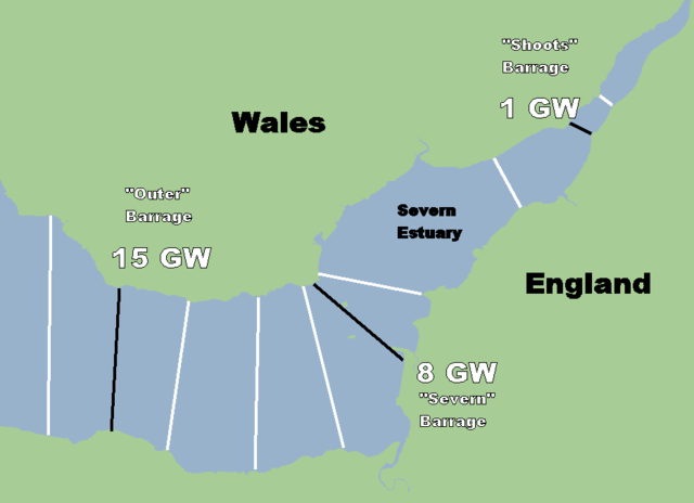
I made this map. It shows barrage locations considered over the years.
Licensing
 |
I, the copyright holder of this work, hereby release it into the public domain. This applies worldwide. In case this is not legally possible, |
File history
Click on a date/time to view the file as it appeared at that time.
| Date/Time | Dimensions | User | Comment | |
|---|---|---|---|---|
| current | 10:46, 3 October 2007 | 932×675 (9 KB) | Fig wright ( Talk | contribs) | (I made this. Update includes names.) |
| revert | 10:38, 3 October 2007 | 932×675 (7 KB) | Fig wright ( Talk | contribs) | (I made this. Update shows barrages of most interest and peak power generated from those locations) |
| revert | 10:57, 24 May 2007 | 932×675 (5 KB) | Fig wright ( Talk | contribs) | (I made this map. It shows barrage locations considered over the years.) |
See the setup instructions for more information.
File links
The following pages on Schools Wikipedia link to this image (list may be incomplete):
Categories: Map images that should be in SVG format | Copy to Wikimedia Commons | User-created public domain images