Image:RiverSevernMap.jpg
From Wikipedia, the free encyclopedia
Size of this preview: 540 × 480 pixels
Full resolution (871 × 774 pixels, file size: 389 KB, MIME type: image/jpeg)
| Description |
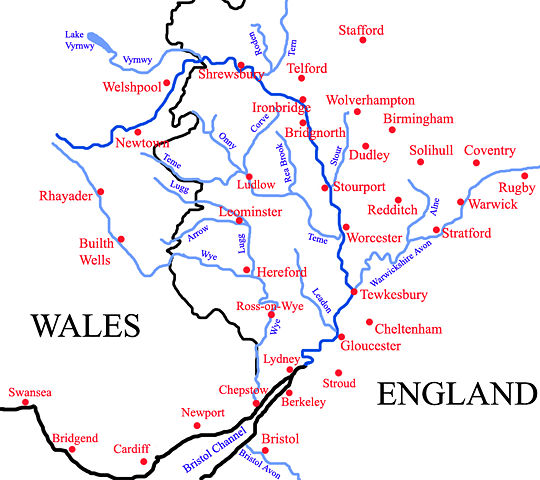
Map of the River Severn, updated version with more Welsh settlements. |
|---|---|
| Source |
self-made |
| Date |
29 March 2008 |
| Author |
ChrisJB ( talk) |
| Permission ( Reusing this image) |
See below. |
| Other versions |  |
Licensing:
|
| |
This file is an exact duplicate of another file from the Wikimedia Commons. Unless it is currently protected from editing, this media file may qualify for speedy deletion if it satisfies these conditions. | |
File history
Click on a date/time to view the file as it appeared at that time.
| Date/Time | Dimensions | User | Comment | |
|---|---|---|---|---|
| current | 22:52, 29 March 2008 | 871×774 (389 KB) | ChrisJB ( Talk | contribs) | ({{Information |Description=Map of the River Severn, updated version with more Welsh settlements. |Source=self-made |Date=29 March 2008 |Location= |Author=~~~ |other_versions= 250px }}) |
See the setup instructions for more information.
File links
The following file is a duplicate of this file:
The following pages on Schools Wikipedia link to this image (list may be incomplete):
Metadata
This file contains additional information, probably added from the digital camera or scanner used to create or digitize it. If the file has been modified from its original state, some details may not fully reflect the modified file.
| Orientation | Normal |
|---|---|
| Horizontal resolution | 72 dpi |
| Vertical resolution | 72 dpi |
| Software used | Adobe Photoshop CS Windows |
| File change date and time | 22:46, 29 March 2008 |
| Colour space | sRGB |
Categories: Creative Commons Attribution 3.0 images | Self-published work