Image:Boston college town map.png
From Wikipedia, the free encyclopedia
Size of this preview: 568 × 480 pixels
Full resolution (1,212 × 1,024 pixels, file size: 986 KB, MIME type: image/png)
| |
This is a file from the Wikimedia Commons. The description on its description page there is shown below. |
| Description |
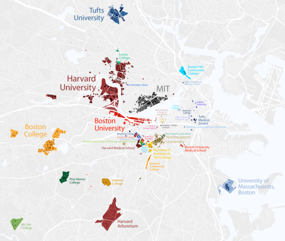
Map of colleges and universities in the Boston, Massachusetts area |
|---|---|
| Source |
http://www.radicalcartography.net/?boston_campus |
| Date |
2007 |
| Author |
Bill Rankin |
| Permission ( Reusing this image) |
All maps, text, and images are released under the Creative Commons License 2.0 – you are free to use, quote, or manipulate anything you want, as long as you give attribution and the terms of the license.
|
| |
This file is licensed under Creative Commons Attribution 2.0 License |
File history
Click on a date/time to view the file as it appeared at that time.
| Date/Time | Dimensions | User | Comment | |
|---|---|---|---|---|
| current | 19:50, 14 September 2007 | 1,212×1,024 (986 KB) | Dream out loud | ({{Information |Description=Map of colleges and universities in the Boston, Massachusetts area |Source=http://www.radicalcartography.net/?boston_campus |Date= 2007 |Author=Bill Rankin |Permission=All maps, text, and images are released under the) |
File links
The following pages on Schools Wikipedia link to this image (list may be incomplete):