Image:Ancient Levant routes.png
From Wikipedia, the free encyclopedia
Size of this preview: 640 × 433 pixels
Full resolution (919 × 622 pixels, file size: 319 KB, MIME type: image/png)
| |
This is a file from the Wikimedia Commons. The description on its description page there is shown below. |
| Description |
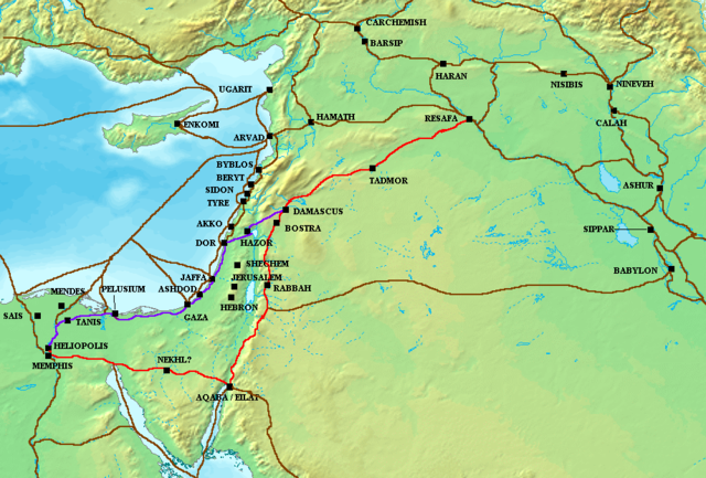
The en:Via Maris (purple), King's Highway (in red), and other ancient en:Levantine en:trade routes, c. en:1300 BCE en:Category:Historical maps by User:Briangotts |
|---|---|
| Source |
Originally from en.wikipedia; description page is/was here. |
| Date |
2006-05-24 (original upload date) |
| Author |
Original uploader was Briangotts at en.wikipedia |
| Permission ( Reusing this image) |
Released under the GNU Free Documentation License.
|
License information
|

Original upload log
(All user names refer to en.wikipedia)
- 2006-05-24 18:48 Briangotts 919×622×8 (326236 bytes) The [[Via Maris]] (purple), [[King's Highway (ancient)|King's Highway]] (in red), and other ancient [[Levant]]ine [[trade route]]s, c. 1300 BCE]] [[Category:Historical maps by User:Briangotts]]
File history
Click on a date/time to view the file as it appeared at that time.
| Date/Time | Dimensions | User | Comment | |
|---|---|---|---|---|
| current | 15:15, 20 July 2007 | 919×622 (319 KB) | Briangotts | ({{Information |Description The Via Maris (purple), King's Highway (in red), and other ancient Levantine trade routes, c. 1300 BCE. |Source=self-made |Date= |Author= Briangotts }} [[Category:) |
| 18:09, 18 June 2007 | 919×622 (319 KB) | Matthiasb | ({{Information |Description=The en:Via Maris (purple), King's Highway (in red), and other ancient en:Levantine en:trade routes, c. en:1300 BCE en:Category:Historical maps by User:Briangotts |Source) |