Image:Southeast mediterranean annotated geography.jpg
From Wikipedia, the free encyclopedia
Size of this preview: 220 × 479 pixels
Full resolution (831 × 1,809 pixels, file size: 525 KB, MIME type: image/jpeg)
| |
This is a file from the Wikimedia Commons. The description on its description page there is shown below. |
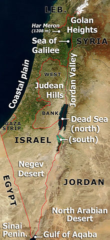
Annotated satellite image of Israel, the Palestinian territories and western Jordan, highlighting principal geographical features.
Based on Image:Satellite image of Israel in January 2003.jpg
If anyone wants to adapt this for a different language, please contact me ( ChrisO) - I can send the original .PSD file.
Licensing
 |
This file is in the public domain because it was created by NASA. NASA copyright policy states that "NASA material is not protected by copyright unless noted". ( NASA copyright policy page or JPL Image Use Policy). Deutsch | English | Español | Français | Galego | Nederlands | Português | Русский | 中文(简体) | 中文(繁體) | +/- |
|
 |
Warnings:
|
|
|
I, the copyright holder of this work, hereby release it into the public domain. This applies worldwide. In case this is not legally possible: Afrikaans | Alemannisch | Aragonés | العربية | Asturianu | Български | Català | Cebuano | Česky | Cymraeg | Dansk | Deutsch | Eʋegbe | Ελληνικά | English | Español | Esperanto | Euskara | Estremeñu | فارسی | Français | Galego | 한국어 | हिन्दी | Hrvatski | Ido | Bahasa Indonesia | Íslenska | Italiano | עברית | Kurdî / كوردی | Latina | Lietuvių | Latviešu | Magyar | Македонски | Bahasa Melayu | Nederlands | Norsk (bokmål) | Norsk (nynorsk) | 日本語 | Polski | Português | Ripoarisch | Română | Русский | Shqip | Slovenčina | Slovenščina | Српски / Srpski | Suomi | Svenska | ไทย | Tagalog | Türkçe | Українська | Tiếng Việt | Walon | 中文(简体) | 中文(繁體) | zh-yue-hant | +/- |
File history
Click on a date/time to view the file as it appeared at that time.
| Date/Time | Dimensions | User | Comment | |
|---|---|---|---|---|
| current | 21:24, 27 March 2007 | 831×1,809 (525 KB) | ChrisO | (Annotated satellite image of Israel, the Palestinian territories and western Jordan, highlighting principal geographical features. Based on Image:Satellite image of Israel in January 2003.jpg ''If anyone wants to adapt this for a different language) |