Image:4516-Oxford-map-1510x1384.jpg
From Wikipedia, the free encyclopedia
Size of this preview: 523 × 479 pixels
Full resolution (1,510 × 1,384 pixels, file size: 506 KB, MIME type: image/jpeg)
Summary
public domain image from http://fromoldbooks.org/HarmsworthEncyclopaedia/pages/4516-Oxford-map/1510x1384.html
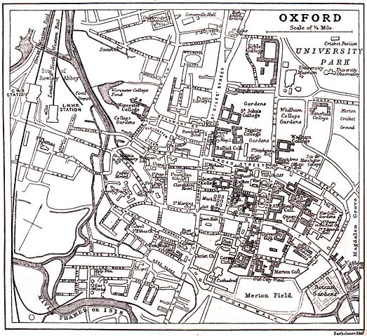
"Overview map of Oxford from 1900 or so, showing the River Thames of Isis, giving the names of almost all the streets, marking the colleges of Oxford University, the railway and other items."
Note that Christ Church College is not shaded as a college, for unknown reasons.
Licensing
 |
This image is in the public domain because its copyright has expired in the United States and those countries with a copyright term of no more than the life of the author plus 100 years. |
File history
Click on a date/time to view the file as it appeared at that time.
| Date/Time | Dimensions | User | Comment | |
|---|---|---|---|---|
| current | 01:32, 21 October 2005 | 1,510×1,384 (506 KB) | Roke ( Talk | contribs) | (public domain image from http://fromoldbooks.org/HarmsworthEncyclopaedia/pages/4516-Oxford-map/1510x1384.html) |
See the setup instructions for more information.
File links
The following pages on Schools Wikipedia link to this image (list may be incomplete):
Categories: Author died more than 100 years ago public domain images | Images of Oxford | Streets in Oxford | Squares in Oxford