Image:Mediterranean Sea political map-en.svg
From Wikipedia, the free encyclopedia
Mediterranean_Sea_political_map-en.svg (SVG file, nominally 2,046 × 1,496 pixels, file size: 1.1 MB)
| |
This is a file from the Wikimedia Commons. The description on its description page there is shown below. |
Summary
| Description |
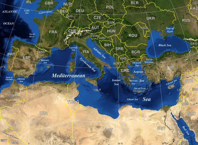
Map in English of the Mediterranean Sea, with the borders and the name of the States following the ISO 3166-1 Alpha-3 code. |
|---|---|
| Source |
Own work ; |
| Date |
June 2007 |
| Author |
Eric Gaba ( Sting) |
| Permission ( Reusing this image) |
All rights released |
| Other versions | completely blank : Image:Mediterranian_Sea_16.61811E_38.99124N.jpg ; blank with State borders : Image:Mediterranean_Sea_political_map-blank.svg ; in French : Image:Mediterranean_Sea_political_map-fr.svg |
- Sujet : Carte en anglais de la Mer Méditerranée avec les frontières et les noms des États suivant le code ISO 3166-1 Alpha-3 ;
- Sources : Création personnelle ;
-
- Fond de carte bitmap : Capture d'écran de NASA World Wind (domaine public) ;
- Auteur : Eric Gaba ( fr:Sting) ;
- Date : Juin 2007 ;
- Autres versions :
-
- entièrement vierge : Image:Mediterranian_Sea_16.61811E_38.99124N.jpg ;
- vierge avec frontières : Image:Mediterranean_Sea_political_map-blank.svg.
- en français : Image:Mediterranean_Sea_political_map-fr.svg ;
 |
This SVG file uses embedded text that can be easily translated into your language. Learn more. For SVG images, you can use this page to translate it into your language. العربية | Català | Dansk | Deutsch | English | Esperanto | Español | Français | Galego | Italiano | 日本語 | Lietuvių | Magyar | Nederlands | Polski | Português | Русский | Svenska | Українська | +/- |
Licensing
 |
This image is in the public domain because it is a screenshot from NASA’s globe software World Wind using Blue Marble, Landsat or USGS layer, all of which are in public domain. |
|
| |
This work was previously under Public Domain, or a Free License. It has been digitally enhanced and/or modified. This derivative work has been (or is hereby) released into the public domain by its author, Sting at the French Wikipedia project. This applies worldwide. In some countries this is not legally possible; if so: |
File history
Click on a date/time to view the file as it appeared at that time.
| Date/Time | Dimensions | User | Comment | |
|---|---|---|---|---|
| current | 16:18, 19 May 2008 | 2,046×1,496 (1.1 MB) | Sting | ("Tropic of Cancer" label correction) |
| 01:01, 21 June 2007 | 2,046×1,496 (1.1 MB) | Sting | ({{Information |Description=Map in English of the Mediterranean Sea, with the borders and the name of the States following the ISO 3166-1 Alpha-3 code. |Source=Own work ;<br/>Background map : screenshot from NASA World Wind (Publi) |