Image:European Union accession policies.png
From Wikipedia, the free encyclopedia
Size of this preview: 640 × 467 pixels
Full resolution (748 × 546 pixels, file size: 29 KB, MIME type: image/png)
| |
This is a file from the Wikimedia Commons. The description on its description page there is shown below. |
  It is recommended that the other file be used.
Alemannisch | العربية | Български | Česky | Dansk | Deutsch | English | Ελληνικά | Esperanto | Español | Français | Galego | עברית | हिन्दी | Magyar | Bahasa Indonesia | Italiano | 日本語 | 한국어 | Lietuvių | Nederlands | Norsk (nynorsk) | Norsk (bokmål) | Polski | Português | Română | Русский | Slovenščina | Српски / Srpski | Svenska | Türkçe | 中文(简体) | 中文(繁體) | +/- |
Summary
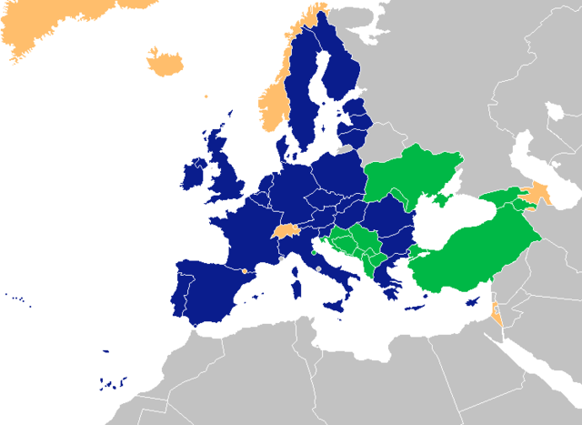
A map showing national governments' policies on EU membership, based on Image:BlankMap-Europe-v4.png.
██ member states
██ membership is declared goal
██ membership under discussion
Licensing
 |
Permission is granted to copy, distribute and/or modify this document under the terms of the GNU Free Documentation license, Version 1.2 or any later version published by the Free Software Foundation; with no Invariant Sections, no Front-Cover Texts, and no Back-Cover Texts. A copy of the license is included in the section entitled " GNU Free Documentation license". Aragonés | العربية | Asturianu | Беларуская (тарашкевіца) | Български | বাংলা | ইমার ঠার/বিষ্ণুপ্রিয়া মণিপুরী | Brezhoneg | Bosanski | Català | Cebuano | Česky | Dansk | Deutsch | Ελληνικά | English | Esperanto | Español | Eesti | Euskara | فارسی | Suomi | Français | Gaeilge | Galego | עברית | Hrvatski | Magyar | Bahasa Indonesia | Ido | Íslenska | Italiano | 日本語 | ქართული | ភាសាខ្មែរ | 한국어 | Kurdî / كوردی | Latina | Lëtzebuergesch | Lietuvių | Bahasa Melayu | Nnapulitano | Nederlands | Norsk (nynorsk) | Norsk (bokmål) | Occitan | Polski | Português | Română | Русский | Slovenčina | Slovenščina | Shqip | Српски / Srpski | Svenska | తెలుగు | ไทย | Tagalog | Türkçe | Українська | اردو | Tiếng Việt | Volapük | Yorùbá | 中文(简体) | 中文(繁體) | +/- |
File history
Click on a date/time to view the file as it appeared at that time.
| Date/Time | Dimensions | User | Comment | |
|---|---|---|---|---|
| current | 16:37, 13 March 2008 | 748×546 (29 KB) | Nightstallion | (upload a variant if you wish, but the majority in Europe recognises or will recognise.) |
| 18:19, 11 March 2008 | 748×546 (20 KB) | Avala | (there is no consensus in European Union) | |
| 23:15, 23 February 2008 | 748×546 (29 KB) | Hoshie | (added Kosovo after a request ) | |
| 15:01, 19 January 2008 | 748×546 (20 KB) | Nightstallion | (slight colour fix) | |
| 17:14, 18 January 2008 | 748×546 (18 KB) | Aivazovsky | (Added Greenland) | |
| 09:34, 18 January 2008 | 748×546 (27 KB) | Nightstallion | (still think the old projection is better) | |
| 00:03, 18 January 2008 | 1,174×1,000 (52 KB) | Aivazovsky | (Kept old colors, changed map) | |
| 17:56, 17 January 2008 | 748×546 (27 KB) | Nightstallion | (Reverted to version as of 17:05, 1 January 2008) | |
| 23:43, 16 January 2008 | 1,174×1,000 (53 KB) | Aivazovsky | ({{Information |Description= |Source= |Date= |Author= |Permission= |other_versions= }} ) | |
| 17:05, 1 January 2008 | 748×546 (27 KB) | Nightstallion | (san marino wants mbmership.) | |
| 01:27, 27 October 2007 | 748×546 (27 KB) | Nightstallion | (this is the better map.) | |
| 13:31, 26 October 2007 | 2,100×1,525 (110 KB) | Valentinian | (Slovenia is already a member.) | |
| 10:12, 17 August 2007 | 2,100×1,525 (78 KB) | Roke | (trying again ) | |
| 10:07, 17 August 2007 | 2,100×1,525 (78 KB) | Roke | (Reverted to earlier revision) | |
| 10:01, 17 August 2007 | 748×546 (27 KB) | Roke | (Reverted to earlier revision) | |
| 09:58, 17 August 2007 | 2,100×1,525 (78 KB) | Roke | (better base map after complaint, same colours) | |
| 11:08, 28 December 2006 | 748×546 (27 KB) | Nightstallion | ||
| 11:00, 14 October 2006 | 748×546 (27 KB) | Nightstallion | ||
| 10:58, 14 October 2006 | 1,357×628 (47 KB) | Nightstallion | (Reverted to earlier revision) | |
| 10:58, 14 October 2006 | 748×546 (27 KB) | Nightstallion | (Reverted to earlier revision) | |
| 10:57, 14 October 2006 | 748×546 (27 KB) | Nightstallion | (Reverted to earlier revision) | |
| 10:57, 14 October 2006 | 1,357×628 (47 KB) | Nightstallion | ||
| 10:56, 14 October 2006 | 748×546 (27 KB) | Nightstallion | (Reverted to earlier revision) | |
| 10:54, 14 October 2006 | 748×546 (27 KB) | Nightstallion | (one more try.) | |
| 10:45, 14 October 2006 | 748×546 (27 KB) | Nightstallion | (liechtenstein, take two) | |
| 10:27, 14 October 2006 | 748×546 (27 KB) | Nightstallion | (liechtenstein) | |
| 21:54, 9 September 2006 | 748×546 (27 KB) | Nightstallion | (israel) | |
| 06:29, 27 June 2006 | 748×546 (27 KB) | Nightstallion | ||
| 06:25, 27 June 2006 | 748×546 (27 KB) | Nightstallion | (better map) | |
| 10:35, 22 June 2006 | 1,060×760 (23 KB) | Nightstallion | ||
| 10:02, 22 June 2006 | 789×570 (15 KB) | Nightstallion | ||
| 09:42, 21 June 2006 | 1,357×628 (46 KB) | Nightstallion | (A map showing national governments' policies on EU membership. {{legend|#003399|member states}} {{legend|#00BF60|membership is declared goal}} {{legend|#FFC884|membership under discussion}} Category:European Union Category:Maps of Europe) |