Image:Egypt-region-map-cities2.gif
From Wikipedia, the free encyclopedia
Size of this preview: 474 × 479 pixels
Full resolution (530 × 536 pixels, file size: 149 KB, MIME type: image/gif)
| |
This file has been listed on Wikipedia:Possibly unfree images because the information on its source or copyright status is disputed. Please see this image's listing for discussion. If you don't want the file deleted, please provide explanatory information about the copyright status of this image. Please do not remove this notice while the question is being considered .
|
 |
This is a candidate to be copied to the Wikimedia Commons. Appropriately licensed media are more accessible to other Wikimedia projects if placed on Commons. Any user may perform this move - please see Moving images to the Commons for more information. Please remove this tag after this image has been copied to Commons. Copy to Commons via CommonsHelper |
Summary
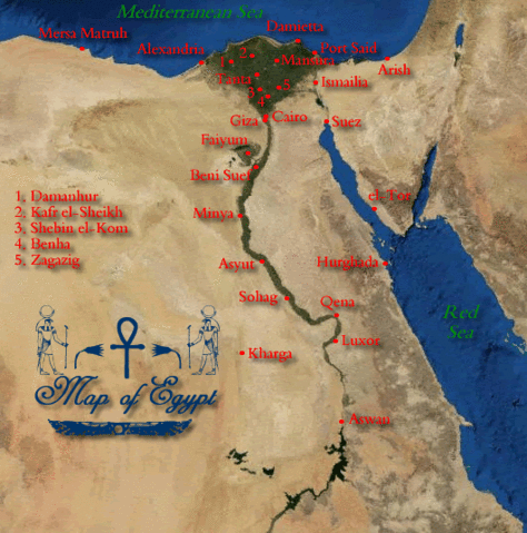
Map of Egypt, showing the capital cities of the 26 governorates, plus the self-governing city of Luxor. Self-created.
Licensing
 |
I, the copyright holder of this work, hereby release it into the public domain. This applies worldwide. In case this is not legally possible, |
Removed from the following pages:
-- OrphanBot ( talk) 05:39, 5 August 2008 (UTC)
File history
Click on a date/time to view the file as it appeared at that time.
| Date/Time | Dimensions | User | Comment | |
|---|---|---|---|---|
| current | 15:40, 12 July 2007 | 530×536 (149 KB) | Lanternix ( Talk | contribs) | (Map of Egypt, showing the capital cities of the governorates. Self created.) |
See the setup instructions for more information.