Image:Swissmap.png
From Wikipedia, the free encyclopedia
Size of this preview: 640 × 421 pixels
Full resolution (972 × 640 pixels, file size: 456 KB, MIME type: image/png)
| |
This is a file from the Wikimedia Commons. The description on its description page there is shown below. |
From en:Image:Swissmap.png, mostly by en:User:Kokiri
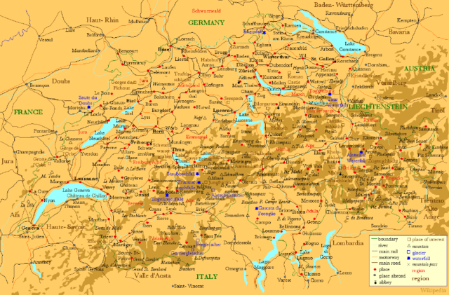
- Description: A map of Switzerland showing places in Switzerland (red) and the neighbouring areas (grey), large lakes (blue) , main rivers (blue), main railways (black), motorways (orange) and places of interest (brown).
- Source: Drawn myself.
New in version 2:
- rivers and lakes now light blue with dark blue labels
- 10 largest cities in bold
- national capitals underlined
- added two motorways around Lake Neuchâtel
- fixed a few inconsistencies and connection points
- removed the 'Battle' out of two historic battle sites
- rendered at a smaller scale for a smaller size
New in version 3:
- corrected spelling of Baden-Württemberg and Vorarlberg
- changed Schwarzwald into a region
- fixed a few inconsistencies
- moved a few names for better readability
New in version 4:
- corrected name of city at lake constance to constance (was Koblenz which is definitely wrong) ( User:Andlaus)
New in version 5:
- added a basic relief showing mountains
- fixed some spelling mistakes
- cropped from larger version: Image:SwissmapFull.png, which is also available.
 |
Permission is granted to copy, distribute and/or modify this document under the terms of the GNU Free Documentation license, Version 1.2 or any later version published by the Free Software Foundation; with no Invariant Sections, no Front-Cover Texts, and no Back-Cover Texts. A copy of the license is included in the section entitled " GNU Free Documentation license". Aragonés | العربية | Asturianu | Беларуская (тарашкевіца) | Български | বাংলা | ইমার ঠার/বিষ্ণুপ্রিয়া মণিপুরী | Brezhoneg | Bosanski | Català | Cebuano | Česky | Dansk | Deutsch | Ελληνικά | English | Esperanto | Español | Eesti | Euskara | فارسی | Suomi | Français | Gaeilge | Galego | עברית | Hrvatski | Magyar | Bahasa Indonesia | Ido | Íslenska | Italiano | 日本語 | ქართული | ភាសាខ្មែរ | 한국어 | Kurdî / كوردی | Latina | Lëtzebuergesch | Lietuvių | Bahasa Melayu | Nnapulitano | Nederlands | Norsk (nynorsk) | Norsk (bokmål) | Occitan | Polski | Português | Română | Русский | Slovenčina | Slovenščina | Shqip | Српски / Srpski | Svenska | తెలుగు | ไทย | Tagalog | Türkçe | Українська | اردو | Tiếng Việt | Volapük | Yorùbá | 中文(简体) | 中文(繁體) | +/- |
File history
Legend: (cur) = this is the current file, (del) = delete this old version, (rev) = revert to this old version. Click on date to download the file or see the image uploaded on that date. (del) (cur) 05:46, 11 June 2005 . . Kokiri (Talk | contribs) . . 972×640 (466,707 bytes) (New Version) (del) (rev) 04:02, 2 August 2004 . . Andlaus (Talk | contribs) . . 1167×767 (234,757 bytes) (corrected map of switzerland (koblenz->constance)) (del) (rev) 14:06, 17 April 2004 . . Kokiri (Talk | contribs) . . 1167×767 (165,508 bytes) (New verision of the large Swiss Map.) (del) (rev) 05:01, 31 March 2004 . . Kokiri (Talk | contribs) . . 1172×765 (168,489 bytes) (del) (rev) 22:30, 29 March 2004 . . Kokiri (Talk | contribs) . . 1560×1038 (252,608 bytes) (A Map of Switzerland, drawn myself.)
File history
Click on a date/time to view the file as it appeared at that time.
| Date/Time | Dimensions | User | Comment | |
|---|---|---|---|---|
| current | 10:30, 29 August 2006 | 972×640 (456 KB) | Maximaximax | (From en:Image:Swissmap.png, mostly by en:User:Kokiri * Description: A map of Switzerland showing places in Switzerland (red) and the neighbouring areas (grey), large lakes (blue) , main rivers (blue), main railways (black), motorways (orang) |