Image:Falkland Islands topographic map-en.svg
From Wikipedia, the free encyclopedia
Falkland_Islands_topographic_map-en.svg (SVG file, nominally 2,550 × 1,990 pixels, file size: 1.93 MB)
| |
This is a file from the Wikimedia Commons. The description on its description page there is shown below. |
| This is a featured picture, which means that members of the community have identified it as one of the finest images on the English Wikipedia, adding significantly to its accompanying article. If you have a different image of similar quality, be sure to upload it using the proper free license tag, add it to a relevant article, and nominate it. |
|
|
This file was a candidate on Picture of the Year 2007. This is a featured picture on Wikimedia Commons: it is considered one of our finest images. This is a featured picture on English Wikipedia and is considered one of the finest images. If you have an image of similar quality that can be published under a suitable copyright license, be sure to upload it, tag it, and nominate it. |
|
![]()
Detailed map of large dimension. For a better viewing, click on the link of the image above.
Carte détaillée de grande dimension. Pour une visualisation optimale, cliquer sur le lien de l'image ci-dessus.
Summary
| Description |
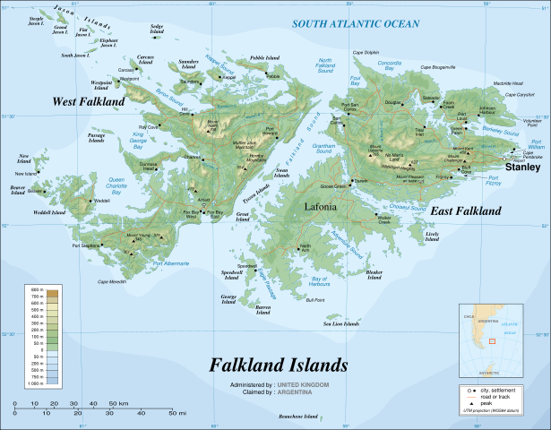
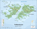
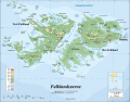
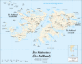
English: The Falkland Islands are an archipelago in the South Atlantic Ocean, located 300 miles off the coast of Argentina. They consist of two main islands, East Falkland and West Falkland, together with about 700 smaller islands. Stanley, on East Falkland, is the capital and largest city. The islands are a self-governing Overseas Territory of the United Kingdom.
Français : Carte topographique en anglais des Îles Malouines. Les Malouines forment un archipel dans l'Océan Atlantique Sud à 480 km des côtes argentines. Il est composé de deux îles principales, East Falkland et West Falkland, et de 700 autres îles et îlots. Stanley, sur East Falkland, est la capitale et la plus grande agglomération de l'archipel. Les Malouines sont un territoire autonome du Royaume-Uni.
Português: Mapa topográfico (em inglês) das Ilhas Malvinas, um arquipélago no sul do Oceano Atlântico, a 300 milhas da costa da Argentina. Consiste de duas ilhas, Soledad a leste e Gran Malvina, a oeste, junto com cerca de 700 outras ilhotas. A capital (e maior cidade) é Stanley. As Malvinas são um território autónomo do Reino Unido.
|
|||||||||||
|---|---|---|---|---|---|---|---|---|---|---|---|---|
| Source |
Own work ; |
|||||||||||
| Date |
November 2007 using elements from the original version of April 2007 |
|||||||||||
| Author |
Eric Gaba ( Sting) |
|||||||||||
| Permission ( Reusing this image) |
GFDL or Creative Commons – Attribution – Share-Alike – 2.5 |
|||||||||||
| Other versions |
|


- Sujet : Carte topographique en anglais des îles Malouines ;
- Sources : Création personnelle
-
- Données topographiques : NASA Shuttle Radar Topography Mission (SRTM3 v.2) (domaine public) édité avec dlgv32 Pro/Global Mapper et vectorisé avec Inkscape ; projection UTM ; WGS84 datum ; relief ombré (image composite d'éclairages du N-O, O et N) ;
- Bathymétrie : Données du gouvernement des ÉUA dans le domaine public fournies par l'add-on Demis pour World Wind (voir le courriel d'approbation) ;
- Autres références utilisées pour les données complémentaires :
-
- NASA World Wind ; Université du Texas à Austin ;
- Atlas Microsoft Encarta (édition 1999) ;
- Échelle approximative :
-
- 1:705 000 (données topographiques et tracés des côtes / lacs) ;
- 1:3 720 000 (bathymétrie) ;
- Note : Le relief ombré est une image bitmap encapsulée dans le fichier SVG qui augmente son poids. Si vous avez besoin d'une carte plus légère pour d'autres utilisations, supprimez l'image du relief ombré dans votre fichier ;
- Auteur : Eric Gaba ( fr:Sting) ;
- Date : Novembre 2007, sur la base d'une version originale d'avril 2007.
- Autre version : francophone : Image:Falkland_Islands_topographic_map-fr.svg
 |
This SVG file uses embedded text that can be easily translated into your language. Learn more. For SVG images, you can use this page to translate it into your language. العربية | Català | Dansk | Deutsch | English | Esperanto | Español | Français | Galego | Italiano | 日本語 | Lietuvių | Magyar | Nederlands | Polski | Português | Русский | Svenska | Українська | +/- |
Licensing
|

File history
Click on a date/time to view the file as it appeared at that time.
| Date/Time | Dimensions | User | Comment | |
|---|---|---|---|---|
| current | 03:38, 14 November 2007 | 2,550×1,990 (1.93 MB) | Sting | (New version more accurate and with shaded relief) |
| 01:18, 16 June 2007 | 2,550×1,990 (1.03 MB) | Sting | (Reverted to earlier revision) | |
| 01:03, 16 June 2007 | 2,550×1,990 (2.14 MB) | Sting | (Trying to fix the bug on WP-en #8) | |
| 00:40, 16 June 2007 | 2,550×1,990 (2.01 MB) | Sting | (Trying to fix the bug on WP-en #7 (really boring...)) | |
| 00:29, 16 June 2007 | 2,550×1,990 (2.08 MB) | Sting | (Trying to fix the bug on WP-en #6 (OK, the problem comes from the shaded relief raster image)) | |
| 00:20, 16 June 2007 | 2,550×1,990 (1.03 MB) | Sting | (Trying to fix the bug on WP-en #5) | |
| 00:18, 16 June 2007 | 2,550×1,990 (2 MB) | Sting | (Trying to fix the bug on WP-en #4) | |
| 00:09, 16 June 2007 | 2,550×1,990 (2 MB) | Sting | (Trying to fix the bug on WP-en #3) | |
| 23:59, 15 June 2007 | 2,550×1,990 (2.03 MB) | Sting | (Trying to fix the bug on WP-en #2) | |
| 23:22, 15 June 2007 | 2,550×1,990 (2 MB) | Sting | (Trying to fix the bug on WP-en) | |
| 01:46, 5 May 2007 | 2,550×1,990 (2.03 MB) | Sting | ("Grantham Sound" : forgotten translation) | |
| 15:10, 2 May 2007 | 2,550×1,990 (2.03 MB) | Sting | (Taking out old demographic data) | |
| 18:37, 5 April 2007 | 2,550×1,990 (2.03 MB) | Sting | (Enhanced shaded relief) | |
| 04:54, 5 April 2007 | 2,550×1,990 (1.85 MB) | Sting | ||
| 04:29, 5 April 2007 | 2,550×1,990 (1.86 MB) | Sting | (Again) | |
| 04:02, 5 April 2007 | 2,550×1,990 (1.93 MB) | Sting | (Again) | |
| 03:56, 5 April 2007 | 2,550×1,990 (1.93 MB) | Sting | (Same display problem) | |
| 03:38, 5 April 2007 | 2,550×1,990 (1.93 MB) | Sting | (Forgotten text) | |
| 03:18, 5 April 2007 | 2,550×1,990 (1.93 MB) | Sting | (New try) | |
| 03:03, 5 April 2007 | 2,550×1,990 (1.06 MB) | Sting | (Upload without shaded relief) | |
| 02:50, 5 April 2007 | 2,550×1,990 (1.86 MB) | Sting | (Display bug) | |
| 02:36, 5 April 2007 | 2,550×1,990 (1.86 MB) | Sting | ({{Information |Description={{en}}The '''Falkland Islands''' are an archipelago in the South Atlantic Ocean, located 300 miles off the coast of Argentina. They consist of two main islands, East Falkland and West Falkland, together with about 700 smalle) |