Image:Keurusselka-WorldWind.jpg
From Wikipedia, the free encyclopedia
Size of this preview: 331 × 480 pixels
Full resolution (563 × 816 pixels, file size: 183 KB, MIME type: image/jpeg)
| |
This is a file from the Wikimedia Commons. The description on its description page there is shown below. |
Summary
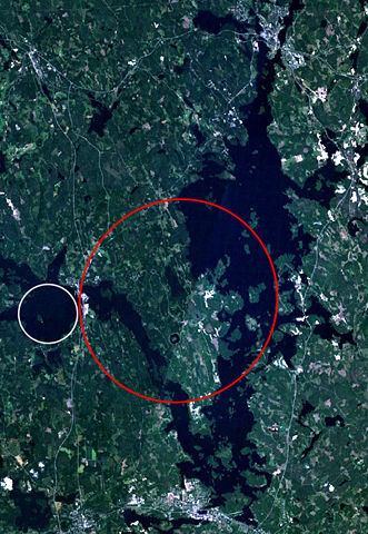
| Description |
Landsat 7 satellite image of the Keurusselkä lake region. Keurusselkä impact structure is marked with a red ellipse, suggested impact structure of Ukonselkä is marked with a white circle |
|---|---|
| Source |
NASA WorldWind; data based on J. Moilanen's map and the SEIS database |
| Date |
6/5/2006 |
| Author |
NASA |
| Permission ( Reusing this image) |
NASA PD
|
Licensing
 |
This image is in the public domain because it is a screenshot from NASA’s globe software World Wind using Blue Marble, Landsat or USGS layer, all of which are in public domain. |
|
File history
Click on a date/time to view the file as it appeared at that time.
| Date/Time | Dimensions | User | Comment | |
|---|---|---|---|---|
| current | 17:45, 6 May 2006 | 563×816 (183 KB) | Jyril | ({{Information| |Description=Landsat 7 satellite image of the Keurusselkä lake region. Keurusselkä impact structure has been marked with red circle, suggested impact structure of Ukonselkä is marked with white circle |Source=NASA WorldWind; data based o) |
File links
The following pages on Schools Wikipedia link to this image (list may be incomplete):
Metadata
This file contains additional information, probably added from the digital camera or scanner used to create or digitize it. If the file has been modified from its original state, some details may not fully reflect the modified file.
| Orientation | Normal |
|---|---|
| Horizontal resolution | 72 dpi |
| Vertical resolution | 72 dpi |
| Software used | Adobe Photoshop CS Windows |
| File change date and time | 20:36, 6 May 2006 |
| Colour space | sRGB |