Image:Buryanall copy.jpg
From Wikipedia, the free encyclopedia
Size of this preview: 640 × 329 pixels
Full resolution (1,094 × 563 pixels, file size: 170 KB, MIME type: image/jpeg)
Summary
| Description |
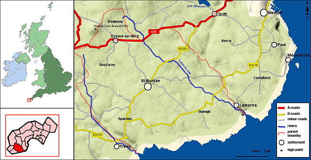
Map of St Buryan Parish.
|
|---|---|
| Source |
self-made |
| Date |
130108 |
| Author |
Mammal4 |
| Permission ( Reusing this image) |
See below. |
Licensing
|
File history
Click on a date/time to view the file as it appeared at that time.
| Date/Time | Dimensions | User | Comment | |
|---|---|---|---|---|
| current | 18:42, 9 March 2008 | 1,094×563 (170 KB) | Mammal4 ( Talk | contribs) | (Updated with extra maps ~~~~) |
| revert | 18:40, 9 March 2008 | 1,094×563 (115 KB) | Mammal4 ( Talk | contribs) | (Modified version of Buryan parish map containing extra location detail ~~~~) |
| revert | 21:34, 13 January 2008 | 837×563 (146 KB) | Mammal4 ( Talk | contribs) | ({{Information |Description= map of St Buryan Parish Topographical data derived from NASA SRTM, PD Roads, Rivers and location data derived from 1890 OS mapping. |Source=self-made |Date=130108 |Location= |Author=Mammal4 |Permission= |other_versions= }}) |
See the setup instructions for more information.
File links
The following pages on Schools Wikipedia link to this image (list may be incomplete):
Metadata
This file contains additional information, probably added from the digital camera or scanner used to create or digitize it. If the file has been modified from its original state, some details may not fully reflect the modified file.
| Orientation | Normal |
|---|---|
| Horizontal resolution | 72 dpi |
| Vertical resolution | 72 dpi |
| Software used | Adobe Photoshop 7.0 |
| File change date and time | 18:41, 9 March 2008 |
| Colour space | 65535 |
Categories: GFDL images | Creative Commons Attribution 3.0 images | Self-published work