Image:1815 Tambora Sumbawa explosion path large.jpg
From Wikipedia, the free encyclopedia
No higher resolution available.
1815_Tambora_Sumbawa_explosion_path_large.jpg (570 × 287 pixels, file size: 27 KB, MIME type: image/jpeg)
Summary
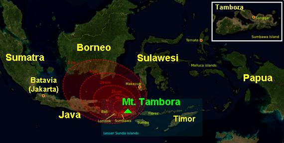
Map of 5 April-11, 1815 Mount Tambora eruption, on the island of Sumbawa in Indonesia, with explosion path and fallout around the caldera. The red ring-areas are graduated bands of the thickness of volcanic ashfall. The explosion had 4 times the energy of the later Krakatoa eruption, in 1883.
(Map is re-labeled with 14 & 12-size Arial font. The image is JPEG format, 9x times faster than the large PNG-format version, and is intended for use in frequently-read articles.)
Source: The base map was taken from NASA picture Image:Indonesia_BMNG.png and the isopach maps were traced from Oppenheimer (2003).
Variation: Image:1815 tambora explosion.png (12x slower file, small lettering).
Licensing
| |
Permission is granted to copy, distribute and/or modify this document under the terms of the GNU Free Documentation License, Version 1.2 or any later version published by the Free Software Foundation; with no Invariant Sections, no Front-Cover Texts, and no Back-Cover Texts. |
File history
Click on a date/time to view the file as it appeared at that time.
| Date/Time | Dimensions | User | Comment | |
|---|---|---|---|---|
| current | 13:56, 28 January 2007 | 570×287 (27 KB) | Wikid77 ( Talk | contribs) | (Map of April 5-11, 1815 Mount Tambora eruption, on the island of Sumbawa in Indonesia, with explosion path and fallout around the caldera. The red ring-areas are graduated bands of the thickness of volcanic ashfall. Th) |
See the setup instructions for more information.