Image:PeriplusMap.jpg
From Wikipedia, the free encyclopedia
Size of this preview: 640 × 351 pixels
Full resolution (3,507 × 1,921 pixels, file size: 1.23 MB, MIME type: image/jpeg)
| |
This is a file from the Wikimedia Commons. The description on its description page there is shown below. |
Summary
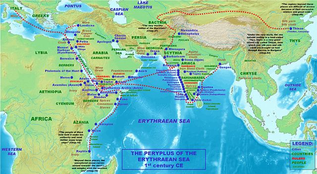
| Description |
Locations, names and routes of the Periplus of the Erythraean Sea (1st century CE). |
|---|---|
| Source |
self-made, background topographical map from Wikipedia Commons Image:Topographic30deg N0E60.png |
| Date |
2007 |
| Author |
PHGCOM |
| Permission ( Reusing this image) |
see below
|
Licensing
|

File history
Click on a date/time to view the file as it appeared at that time.
| Date/Time | Dimensions | User | Comment | |
|---|---|---|---|---|
| current | 19:02, 17 July 2007 | 3,507×1,921 (1.23 MB) | PHGCOM | (Better map) |
| 21:10, 10 July 2007 | 3,511×1,924 (1.24 MB) | PHGCOM | (Better map) | |
| 20:23, 9 July 2007 | 6,591×3,601 (3.37 MB) | PHGCOM | (Better map) | |
| 19:57, 1 July 2007 | 3,505×1,913 (1.21 MB) | PHGCOM | (Better map.) | |
| 13:15, 1 July 2007 | 3,496×1,918 (1.19 MB) | PHGCOM | ({{Information |Description=Locations, names and routes of the Periplus of the Erythraean Sea (1st century CE). |Source=self-made, background topographical map from Wikipedia Commons Image:Topographic30deg N0E60.png |Date=2007 |Author= [[User:PHGCOM|) |