Image:Nigeria veg 1979.jpg
From Wikipedia, the free encyclopedia
Size of this preview: 504 × 480 pixels
Full resolution (734 × 699 pixels, file size: 129 KB, MIME type: image/jpeg)
| |
This is a file from the Wikimedia Commons. The description on its description page there is shown below. |
Summary
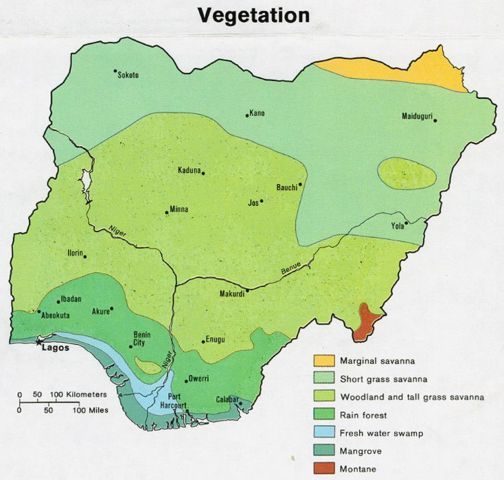
- Description: Map of the vegetation of Nigeria.
- Author: Central Intelligene Agency, CIA
- Source: Perry-Castañeda Library Map Collection
- Map page: Nigeria maps
- License: Public domain
Licensing
 |
This image is a work of a Central Intelligence Agency employee, taken or made during the course of the person's official duties. As a Work of the United States Government, all images created or made by the CIA are in the public domain, with the exception of classified information. |  |
 |
This map image should be recreated using vector graphics as an SVG file. This has several advantages; see Commons:Media for cleanup for more information. If an SVG form of this image is already available, please upload it. After uploading an SVG, replace this template with {{ vector version available|new image name.svg}}. |
|
العربية | Български | Català | Česky | Dansk | Deutsch | English | Esperanto | Español | Français | Galego | 한국어 | Italiano | Magyar | Lietuvių | Nederlands | 日本語 | Polski | Português | Română | Русский | Suomi | Svenska | Türkçe | Українська | 中文(繁體) | 中文(简体) | +/- |
|
Licensing
| |
This work is in the public domain in the United States because it is a work of the United States Federal Government under the terms of Title 17, Chapter 1, Section 105 of the US Code. See Copyright. Note: This only applies to works of the Federal Government and not to the work of any individual U.S. state, territory, commonwealth, county, municipality, or any other subdivision. This template also does not apply to postage stamps published by the United States Postal Service. (See 206.02(b) of Compendium II: Copyright Office Practices). العربية | Български | Česky | Deutsch | English | Español | Français | Magyar | Italiano | 日本語 | 한국어 | Polski | Português | 中文(繁體) | 中文(简体) | +/- |
 |
File history
Click on a date/time to view the file as it appeared at that time.
| Date/Time | Dimensions | User | Comment | |
|---|---|---|---|---|
| current | 23:51, 28 June 2006 | 734×699 (129 KB) | Gozar | (*Description: Map of the vegetation of Nigeria. *Author: Central Intelligene Agency, CIA *Source: Perry-Castañeda Library Map Collection [http://www.lib.utexas.edu/usage_statement.html?maps=yes] *Map page: [http://www.lib.utexas.edu/maps/nigeria.html Ni) |
File links
Metadata
This file contains additional information, probably added from the digital camera or scanner used to create or digitize it. If the file has been modified from its original state, some details may not fully reflect the modified file.
| Orientation | Normal |
|---|---|
| Horizontal resolution | 150 dpi |
| Vertical resolution | 150 dpi |
| Software used | Adobe Photoshop 7.0 |
| File change date and time | 11:12, 8 April 2004 |
| Colour space | 65535 |