St Michael's Mount
2008/9 Schools Wikipedia Selection. Related subjects: Geography of Great Britain
| St Michael's Mount | |
| Cornish: Carrack Looz en Cooz | |
|
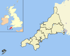
St Michael's Mount shown within Cornwall |
|
| Area | 0.09 sq mi (0.2 km²) |
|---|---|
| OS grid reference | |
| - London | 290 miles (467 km) |
| Parish | St Michael's Mount |
| District | Penwith |
| Shire county | Cornwall |
| Region | South West |
| Constituent country | England |
| Sovereign state | United Kingdom |
| Post town | MARAZION |
| Postcode district | TR17 |
| Dialling code | 01736 |
| Police | Devon and Cornwall |
| Fire | Cornwall |
| Ambulance | South Western |
| European Parliament | South West England |
| UK Parliament | St Ives |
| Website: http://www.stmichaelsmount.co.uk/ | |
| List of places: UK • England • Cornwall | |
Coordinates:
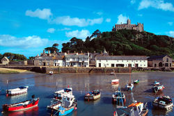
St Michael's Mount (also known as Mont St Michel); Cornish: Carrack Looz en Cooz) is a lofty pyramidal tidal island, exhibiting a curious combination of slate and granite, rising 400 yards (366 m) from the shore of Mount's Bay, situated in Penwith in west Cornwall, United Kingdom, in the extreme south western peninsula of the island of Great Britain. It is united with Marazion by a man-made causeway, passable only at mid to low tide, comprised of granite setts.
Its Cornish language name — literally, "the grey rock in the wood" — may represent a folk memory of a time before Mount's Bay was flooded. Certainly, the Cornish name would be an accurate description of the Mount set in woodland. Remains of trees have been seen at low tides following storms on the beach at Perranuthnoe. The Cornish legend of Lyonesse, an ancient kingdom said to have extended from Penwith toward the Isles of Scilly, also talks of land being inundated by the sea.
Historically, St Michael's Mount was a Cornish counterpart of Mont Saint Michel in Normandy, France.
St Michael's Mount is known colloquially by locals as simply the Mount.
The island today
The chapel is extra-diocesan, and the castle is the official residence of Lord St Levan. Many relics, chiefly armour and antique furniture, are preserved in the castle. The chapel of St Michael, a fifteenth century building, has an embattled tower, in one angle of which is a small turret, which served for the guidance of ships. Chapel Rock, on the beach, marks the site of a shrine dedicated to the Virgin Mary, where pilgrims paused to worship before ascending the Mount. A few houses are built on the hillside facing Marazion, and a spring supplies them with water. The harbour, widened in 1823 to allow vessels of 500 tons to enter, has a pier dating from the fifteenth century and subsequently enlarged and restored.
St Michael's Mount is still owned by the St Aubyn family, but visitor access is controlled by the National Trust.
History
The Mount may be the Mictis of Timaeus, mentioned by Pliny the Elder in his Naturalis Historia (IV:XVI.104), and the Ictis of Diodorus Siculus. Both men had access to the now lost texts of the ancient Greek Geographer Pytheas, who visited the island in the fourth century BCE. If this is true, it is one of the earliest identified locations in the whole of western Europe and particularly on the island of Britain.
It may have been held by a religious body in the time of Edward the Confessor and given by Robert, Count of Mortain to the Norman abbey of Mont Saint Michel. It was a priory of that abbey until the dissolution of the alien houses by Henry V, when it was given to the abbess and Convent of Syon at Isleworth, Middlesex. It was a resort of pilgrims, whose devotions were encouraged by an indulgence granted by Pope Gregory in the 11th century.
Henry Pomeroy captured the Mount, on behalf of Prince John, in the reign of Richard I. John de Vere, 13th Earl of Oxford, seized and held it during a siege of 23 weeks against 6,000 of Edward IV's troops in 1473. Perkin Warbeck occupied the Mount in 1497. Humphry Arundell, governor of St Michael's Mount, led the rebellion of 1549. During the reign of Queen Elizabeth, it was given to Robert Cecil, Earl of Salisbury, by whose son it was sold to Sir Francis Basset. During the Civil War, Sir Arthur Basset, brother of Sir Francis, held the Mount against the parliament until July 1646.
In 1755 the Lisbon earthquake caused a tsunami to strike the Cornish coast over 1,000 miles away. The sea rose six feet in 10 minutes at St Michael's Mount, ebbed at the same rate, and continued to rise and fall for five hours. The 19th-century French writer Arnold Boscowitz claimed that "great loss of life and property occurred upon the coasts of Cornwall."
In the late 19th century, the skeleton of a royalist soldier was discovered when a secret chamber was found in the castle. The soldier had apparently starved to death: a jug of stagnant water was found next to his remains. The Mount was sold in 1659 to Colonel John St Aubyn. His descendant, Lord St Levan, continues to be the "tenant" of the Mount but has ceased to be resident there, his nephew, James St Aubyn, taking up residency and management of the Mount in 2004.
Local government
St Michael's Mount forms its own civil parish for local government purposes. Currently, this takes the form of a parish meeting as opposed to a parish council (that is, a yearly meeting of electors that does not elect councillors). The current chairman of the St Michael's Mount parish meeting is James St Aubyn.
In popular culture
" Mt Saint Michel + Saint Michaels Mount" is the title of an experimental electronic track by musician Aphex Twin, who grew up in Cornwall.
St Michael's Mount, along with Mont Saint-Michel, was an inspiration for the design of Minas Tirith in the 2003 film The Lord of the Rings: The Return of the King, directed by Peter Jackson. St Michael's Mount was also used in the 2002 film Johnny English as the exterior of the character Pascal Sauvage's French chateau.


