Laos
2008/9 Schools Wikipedia Selection. Related subjects: Asia; Asian Countries
| ສາທາລະນະລັດ ປະຊາທິປະໄຕ ປະຊາຊົນລາວ Sathalanalat Paxathipatai Paxaxon Lao Lao People's Democratic Republic |
||||||
|---|---|---|---|---|---|---|
|
||||||
| Motto: ສັນຕິພາບ ເອກະລາດ ປະຊາທິປະໄຕ ເອກະພາບ ວັດທະນາຖາວອນ "Peace, Independence, Democracy, Unity and Prosperity" |
||||||
| Anthem: Pheng Xat Lao |
||||||
|
|
||||||
| Capital (and largest city) |
Vientiane |
|||||
| Official languages | Lao | |||||
| Demonym | Laotian, Lao | |||||
| Government | Socialist Republic | |||||
| - | President | Lt. Gen. Choummaly Sayasone | ||||
| - | Prime Minister | Bouasone Bouphavanh | ||||
| Independence | from France | |||||
| - | Date | 19 July 1949 | ||||
| Area | ||||||
| - | Total | 236,800 km² ( 83rd) 91,429 sq mi |
||||
| - | Water (%) | 2 | ||||
| Population | ||||||
| - | 2007 estimate | 6,521,998 ( 106th) | ||||
| - | 1995 census | 4,574,848 | ||||
| - | Density | 25/km² ( 177th) 65/sq mi |
||||
| GDP ( PPP) | 2006 estimate | |||||
| - | Total | $13.75 billion ( 129th) | ||||
| - | Per capita | $2,200 ( 138th) | ||||
| Gini (2002) | 34.6 (medium) | |||||
| HDI (2007) | ▲ 0.601 (medium) ( 130th) | |||||
| Currency | Kip ( LAK) |
|||||
| Time zone | ( UTC+7) | |||||
| Internet TLD | .la | |||||
| Calling code | [[+ 856]] | |||||
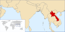
Laos (pronounced /ˈlɑːoʊs/ or /ˈlaʊs/), officially the Lao People's Democratic Republic, is a landlocked country in southeast Asia, bordered by Burma (Myanmar) and China to the northwest, Vietnam to the east, Cambodia to the south, and Thailand to the west. Laos traces its history to the Kingdom of Lan Xang or Land of a Million Elephants, which existed from the fourteenth to the eighteenth century. After a period as a French protectorate, it gained independence in 1949. A long civil war ended officially when the communist Pathet Lao movement came to power in 1975 but the protesting between factions continued for several years.
Private enterprise has increased since the late 1990s when economic reforms including rapid business licensing were introduced. Laos is still ranked among the lowest countries in terms of economic and political freedom. The economy of Laos grew at 7.2% in 2006, 35th fastest in the world. Eighty percent of the employed practice subsistence agriculture. The country's ethnic make-up is diverse, with around 70% belonging to the largest ethnic group, the Lao.
Etymology
In the Lao language, the country's name is "Meuang Lao". The Imperial French, who made the country part of French Indochina in 1893, spelled it with a final silent "s", i.e. "Laos" (The Lao language itself has no final 's' sound, so Lao people do not pronounce the word Laos). The usual adjectival form is "Lao", e.g. "the Lao economy", not the "Laotian" economy--although "Laotian" is used to describe the people of Laos to avoid confusion with the Lao ethnic group.
History
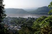
Laos traces its history to the kingdom of Lan Xang, founded in the fourteenth century by Fa Ngum, himself descended from a long line of Lao kings, tracking back to Khoun Boulom. Lan-Xang prospered until the eighteenth century, when the kingdom was divided into three principalities, which eventually came under Siamese suzerainty. In the 19th century, Luang Prabang was incorporated into the 'Protectorate' of French Indochina, and shortly thereafter, the kingdom of Champassack and the territory of Vientiane were also added to the protectorate. The French saw Laos as a useful buffer state between the two expanding empires of France and Britain. Under the French, Vientiane once again became the capital of a unified Lao state. Following a brief Japanese occupation during World War II, the country declared its independence in 1945, but the French under De Gaulle re-asserted their control and only in 1950 was Laos granted semi-autonomy as an "associated state" within the French Union. Moreover, the French remained in de facto control until 1954, when Laos gained full independence as a constitutional monarchy. Under a special exemption to the Geneva Convention, a French military training mission continued to support the Royal Laos Army. In 1955, the U.S. Department of Defense created a special Programs Evaluation Office to replace French support of the Royal Lao Army against the communist Pathet Lao as part of the U.S. containment policy.
Laos was dragged into the Vietnam War, and the eastern parts of the country were invaded and occupied by the North Vietnamese Army (NVA), which used Laotian territory as a staging ground and supply route for its war against the South. In response, the United States initiated a bombing campaign against the North Vietnamese, supported regular and irregular anticommunist forces in Laos and supported a South Vietnamese invasion of Laos. The result of these actions were a series of coups d'état and, ultimately, the Laotian Civil War between the Royal Laotian government and the communist Pathet Lao.
In the Civil War, the NVA, with its heavy artillery and tanks, was the real power behind the Pathet Lao insurgency. In 1968, the North Vietnamese Army launched a multi-division attack against the Royal Lao Army. The attack resulted in the army largely demobilizing and leaving the conflict to irregular forces raised by the United States and Thailand.
Massive aerial bombardment by the United States followed as it attempted to eliminate North Vietnamese bases in Laos in order to disrupt supply lines on the Ho Chi Minh/Trường Sơn Trail. Between 1971 and 1973 the USAF dropped more ordnance on Laos than was dropped worldwide during World War II (1939−45). In total more than 2 million tonnes of bombs were dropped (almost 1/2 a tonne per head of population at the time).
In 1975, the communist Pathet Lao, backed by the Soviet Union and the North Vietnamese Army (justified by the communist ideology of "proletarian internationalism"), overthrew the royalist government, forcing King Savang Vatthana to abdicate on December 2, 1975. He later died in captivity.
After taking control of the country, Pathet Lao's government renamed the country as the "Lao People's Democratic Republic" and signed agreements giving Vietnam the right to station military forces and to appoint advisers to assist in overseeing the country. Laos was ordered in the late 1970s by Vietnam to end relations with the People's Republic of China which cut the country off from trade with any country but Vietnam. Control by Vietnam and socialization were slowly replaced by a relaxation of economic restrictions in the 1980s and admission into ASEAN in 1997.
The Tai Dam are an ethnic group from Laos that escaped the country as a group. After thousands of years of political oppression, the Tai Dam people vowed to unite as one group and find a country they could call their own. The Tai Dam are known as "the people without a country." More than 90 percent of Tai Dam refugees emigrated to the state of Iowa after the governor agreed to take the Tai Dam as a group and have organizations sponsor families. In 2005, the United States established Normal Trade Relations with Laos, ending a protracted period of punitive import taxes.
Provinces and districts
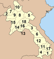
Laos is divided into sixteen provinces (qwang) and Vientiane Capital (Na Kone Luang Vientiane):
1. Attapu
2. Bokeo
3. Bolikhamxai
4. Champasak
5. Houaphan
6. Khammouan
7. Loung Namtha
8. Louangphabang
9. Oudomxai
10. Phongsali
11. Salavan
12. Savannakhet
13. Vientiane Capital
14. Vientiane Province
15. Xaignabouli
16. Xiangkhoang
17. Xekong
The country is further divided into districts (muang).
Geography
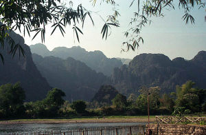
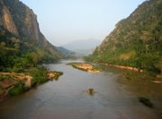
Laos is a landlocked country in Southeast Asia and the thickly forested landscape consists mostly of rugged mountains, the highest of which is Phou Bia at 2,817 m (9,242 feet), with some plains and plateaus. The Mekong River forms a large part of the western boundary with Thailand, whereas the mountains of the Annamite Chain form most of the eastern border with Vietnam.
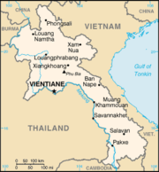
The climate is tropical and monsoonal. There is a distinct rainy season from May to November, followed by a dry season from December to April. Local tradition holds that there are three seasons (rainy, cold and hot) as the latter two months of the climatologically defined dry season are noticeably hotter than the earlier four months. The capital and largest city of Laos is Vientiane, and other major cities include Luang Prabang, Savannakhet and Pakxe.
In 1993, the government set aside 21% of the nation's land area as National Biodiversity Conservation Areas (NBCA), which may be developed into a national park system.
Laos is the home to the Indochinese tiger, the giant gaur, and the Asian elephant. A number of animal species have been discovered or re-discovered in Laos in recent years. These include the striped or Annamite rabbit, the saola, and most recently the Laotian rock rat or kha-nyou.
The country is one of four in the opium poppy growing region known as the " Golden Triangle". According to the October 2007 UNODC fact book "Opium Poppy Cultivation in South East Asia", the poppy cultivation area was 15 square kilometres (3,700 acres), down from 18 square kilometres (4,400 acres) in 2005.
Economy

The government of Laos — one of the few remaining official communist states — began decentralising control and encouraging private enterprise in 1986. The results, starting from an extremely low base, were striking: growth averaged 6% in 1988-2004 except during the short drop caused by the Asian financial crisis beginning in 1997. Major urban centers have experienced the most growth. The economies of Vientiane, Luang Prabang and Savannakhet in particular have experienced significant booms in recent years. The Lao economy is heavily dependent on investment and trade with its larger and richer neighbors, Thailand, Vietnam, and, especially in the north, China. Pakxe has also experienced growth based on cross-border trade with Thailand and Vietnam.
Much of the country, however, lacks adequate infrastructure. Laos has no railways, although a short link to connect Vientiane with Thailand over the Thai-Lao Friendship Bridge is currently under construction. The major roads connecting the major urban centres, in particular Route 13 South, have been significantly upgraded in recent years, but villages far from major roads are accessible only through unpaved roads that may not be accessible year-round. There is limited external and internal telecommunication, particularly of the wire line sort, but mobile cellular phone use has become widespread in urban centres. In many rural areas electricity is unavailable or offered only during scheduled periods. Songthaews (pick-up trucks with benches) are used in the country for long-distance and local public transport.
Subsistence agriculture still accounts for half of GDP and provides 80% of total employment. Laos has the lowest percentage of arable land and permanent crop land in the Greater Mekong Subregion. Only 4.01% of Laos is arable land, and only 0.34% of the country is planted with permanent crops. Rice dominates agriculture, with about 80% of the arable land area used for growing rice. Approximately 77% of Lao farm households are self-sufficient in rice. Through the development, release and widespread adoption of improved rice varieties, and through economic reforms, Lao PDR achieved a net balance of rice imports and exports for the first time in 1999. Between 1990 and 2005, rice production increased from 1.5 million tons to 2.5 million tons : an average annual growth rate of more than 5%. This increase in production has been valued at $8 million to $19 million per year. Lao PDR may have the greatest number of rice varieties in the Greater Mekong Subregion. Since 1995 the Lao government has been working with the International Rice Research Institute (IRRI) to collect seed samples of each of the thousands of rice varieties found in Laos.
The economy receives aid from the IMF and other international sources and from new foreign investment in food processing and mining, most notably of copper and gold. Tourism is the fastest-growing industry in the country. However, economic development in general is hampered by a serious case of brain drain. A 2005 World Bank study reported that 37% of educated Laotians lived abroad, putting the country in fifth place for worst brain drain.
In late 2004, Laos gained Normal Trade Relations status with the US, allowing Laos-based producers to face lower tariffs on their exports; this may help spur growth.
Demographics
69% of the country's people are ethnic Lao, the principal lowland inhabitants and the politically and culturally dominant group. The Lao belong to the Tai linguistic group who began migrating southward from China in the first millennium AD. A further 8% belong to other "lowland" groups, which together with the Lao people make up the Lao Loum.
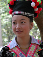
Hill people and minority cultures of Laos such as the Hmong (Miao), Yao (Mien), Tai dumm, Dao, Shan, and several Tibeto-Burman speaking peoples have lived in isolated regions of Laos for many years. Mountain/hill tribes of mixed ethno/cultural-linguistic heritage are found in northern Laos which include the Lua (Lua) and Khammu people who are indigenous to Laos. Today, the Lua people are considered endangered. Collectively, they are known as Lao Soung or highland Laotians. In the central and southern mountains, Mon- Khmer tribes, known as Lao Theung or mid-slope Laotians, predominate. Some Vietnamese and Chinese minorities remain, particularly in the towns, but many left in two waves; after independence in the late 1940s and again after 1975.
The term "Laotian" does not necessarily refer to the ethnic Lao language, ethnic Lao people, language or customs, but is a political term that also includes the non-ethnic Lao groups within Laos and identifies them as "Laotian" because of their political citizenship. In a similar vein, the word "Lao" can also describe the people, cuisine, language and culture of the people of Northeast Thailand (Isan) who are ethnic Lao.
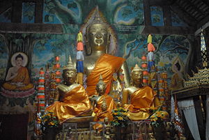
The predominant religion in Laos is Theravada Buddhism which, along with the common Animism practiced among the mountain tribes, coexists peacefully with spirit worship. There also are a small number of Christians, mostly restricted to the Vientiane area, and Muslims, mostly restricted to the Myanmar border region. Christian missionary work is regulated by the government.
The official and dominant language is Lao, a tonal language of the Tai linguistic group. Midslope and highland Lao speak an assortment of tribal languages. French, still common in government and commerce, has declined in usage, while knowledge of English, the language of the Association of Southeast Asian Nations (ASEAN), has increased in recent years.
Culture
Theravada Buddhism is a dominant influence in Lao culture. It is reflected throughout the country from language to the temple and in art, literature, performing arts, etc. Many elements of Lao culture predate Buddhism, however. For example, Laotian music is dominated by its national instrument, the khaen, a type of bamboo pipe that has prehistoric origins. The khaen traditionally accompanied the singer in lam, the dominant style of folk music. Among the various lam styles, the lam saravane is probably the most popular.
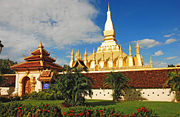
The country has two World Heritage Sites: Luang Prabang and Vat Phou. The government is seeking the same status for the Plain of Jars.
The People's Republic of China has recently allowed its citizens to travel more freely to Laos. As such, Chinese tourists are expected to account for 25% of the total number of visitors to Laos (up from only a few percent) in 2006. Pressures to modernize tourist infrastructure, particularly to cater to package tourism, are expected to significantly impact Luang Prabang and other culturally important Laotian cities. The people of Laos have a reputation for being very kind and welcoming to all visitors.
Rice is the staple food and has cultural and religious significance. There are many traditions and rituals associated with rice production in different environments, and among many ethnic groups. For example, Khammu farmers in Luang Prabang plant the rice variety Khao Kam in small quantities near the hut in memory of dead parents, or at the edge of the rice field to indicate that parents are still alive.
International rankings
| Organisation | Survey | Ranking |
|---|---|---|
| Heritage Foundation/The Wall Street Journal | Index of Economic Freedom | 149 out of 157 |
| Reporters Without Borders | Worldwide Press Freedom Index | 156 out of 167 |
| Transparency International | Corruption Perceptions Index | 111 out of 163 |
| United Nations Development Programme | Human Development Index | 130 out of 177 |


