Image:Kiplingseastcoast2.JPG
From Wikipedia, the free encyclopedia
Size of this preview: 418 × 479 pixels
Full resolution (501 × 574 pixels, file size: 114 KB, MIME type: image/jpeg)
| |
This is a file from the Wikimedia Commons. The description on its description page there is shown below. |
Contents |
Summary
| Description |
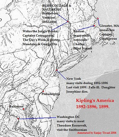
This is a reduced, cropped and version of a physical map of the United States which is in the public domain( ), and downloaded from the University of Texas website: The map was then annotated by me ( Sanjay Tiwari 02:42, 13 October 2006 (UTC)) and is now being released to the public domain. |
|---|---|
| Source |
Originally from en.wikipedia; description page is/was here. |
| Date |
2006-10-13 (original upload date) |
| Author |
Original uploader was Sanjay Tiwari at en.wikipedia |
| Permission ( Reusing this image) |
See license section.
|
License information
 |
I, the copyright holder of this work, hereby release it into the public domain. This applies worldwide. In case this is not legally possible: Afrikaans | Alemannisch | Aragonés | العربية | Asturianu | Български | Català | Cebuano | Česky | Cymraeg | Dansk | Deutsch | Eʋegbe | Ελληνικά | English | Español | Esperanto | Euskara | Estremeñu | فارسی | Français | Galego | 한국어 | हिन्दी | Hrvatski | Ido | Bahasa Indonesia | Íslenska | Italiano | עברית | Kurdî / كوردی | Latina | Lietuvių | Latviešu | Magyar | Македонски | Bahasa Melayu | Nederlands | Norsk (bokmål) | Norsk (nynorsk) | 日本語 | Polski | Português | Ripoarisch | Română | Русский | Shqip | Slovenčina | Slovenščina | Српски / Srpski | Suomi | Svenska | ไทย | Tagalog | Türkçe | Українська | Tiếng Việt | Walon | 中文(简体) | 中文(繁體) | zh-yue-hant | +/- |
Original upload log
(All user names refer to en.wikipedia)
- 2006-10-13 02:42 Sanjay Tiwari 501×574×8 (116822 bytes) This is a reduced, cropped and version of a physical map of the United States which is in the public domain([http://www.lib.utexas.edu/maps/faq.html]), and downloaded from the University of Texas website: [http://www.lib.utexas.edu/maps/national_atlas_197
Licensing
|
|
This image (or other media file) is in the public domain because its copyright has expired. This applies to the United States, Canada, the European Union and those countries with a copyright term of life of the author plus 70 years. العربية | Asturianu | Български | Català | Česky | Dansk | Deutsch | English | Ελληνικά | Esperanto | Español | Euskara | فارسی | Français | Gaeilge | Galego | עברית | हिन्दी | Bahasa Indonesia | Italiano | 日本語 | 한국어 | Kurdî / كوردی | Lietuvių | Magyar | Nederlands | Norsk (nynorsk) | Македонски | Bahasa Melayu | Polski | Português | Română | Русский | Slovenčina | Slovenščina | Shqip | Suomi | Sámegiella | Türkçe | 中文(简体) | 中文(繁體) | 粵語 | +/- |
File history
Click on a date/time to view the file as it appeared at that time.
| Date/Time | Dimensions | User | Comment | |
|---|---|---|---|---|
| current | 23:11, 17 November 2006 | 501×574 (114 KB) | Chechof | ({{Information |Description=This is a reduced, cropped and version of a physical map of the United States which is in the public domain([http://www.lib.utexas.edu/maps/faq.html]), and downloaded from the University of Texas website: [http://www.lib.utexas.) |
File links
Metadata
This file contains additional information, probably added from the digital camera or scanner used to create or digitize it. If the file has been modified from its original state, some details may not fully reflect the modified file.
| Horizontal resolution | 72 dpi |
|---|---|
| Vertical resolution | 72 dpi |
| Software used | Adobe Photoshop 7.0 |
| File change date and time | 13:57, 31 August 2004 |
| Y and C positioning | 2 |
| Exif version | 2.2 |
| Colour space | sRGB |