Image:Kiplingsindia.jpg
From Wikipedia, the free encyclopedia
Size of this preview: 580 × 479 pixels
Full resolution (802 × 663 pixels, file size: 114 KB, MIME type: image/jpeg)
Summary
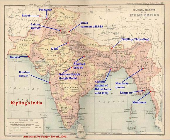
This is a low-resolution (40% of original) scanned image of the map, "Politial Divisions of the Indian Empire" from the Imperial Gazeteer of India (volume 26, Atlas), published by the Oxford University Press, 1909. The map image was scanned and then annotated by me ( Sanjay Tiwari 18:24, 30 September 2006 (UTC))
 |
This image is in the public domain in countries with a copyright term of life of the author plus 70 years or less. Note that the United States has other rules and it is necessary to establish that this image is also in the public domain in the United States or to provide a use rationale. See Template:PD-US. |
Licensing
| |
I, the copyright holder of this work, hereby release it into the public domain. This applies worldwide. In case this is not legally possible, |
|
|
The Wikimedia Commons has another file with the same name as this file. To include the Commons media file in Wikipedia, this locally stored file needs to be renamed. | |
File history
Click on a date/time to view the file as it appeared at that time.
| Date/Time | Dimensions | User | Comment | |
|---|---|---|---|---|
| current | 07:25, 14 May 2007 | 802×663 (114 KB) | Kintetsubuffalo ( Talk | contribs) | (trimmed to make edges equal) |
| revert | 18:24, 30 September 2006 | 880×680 (123 KB) | Sanjay Tiwari ( Talk | contribs) | (This is a low-resolution (40% of original) scanned image of the map, "Politial Divisions of the Indian Empire" from the ''Imperial Gazeteer of India'' (volume 26, Atlas), published by the Oxford University Press, 1909. The map image was scanned and the) |
See the setup instructions for more information.
File links
Metadata
This file contains additional information, probably added from the digital camera or scanner used to create or digitize it. If the file has been modified from its original state, some details may not fully reflect the modified file.
| Image title | LEAD Technologies Inc. V1.01 |
|---|---|
| Horizontal resolution | 200 dpi |
| Vertical resolution | 200 dpi |
| Y and C positioning | 2 |
| Exif version | 2.2 |
| Colour space | sRGB |