Image:Premetro Map3.jpg
From Wikipedia, the free encyclopedia
Size of this preview: 278 × 480 pixels
Full resolution (527 × 909 pixels, file size: 122 KB, MIME type: image/jpeg)
Summary
Summary
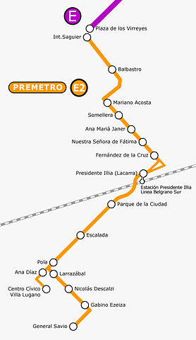
| Description |
Map of Premetro light rail |
|---|---|
| Source |
self-made |
| Date |
04 February 2008 |
| Author |
Moebiusuibeom |
| Permission ( Reusing this image) |
See below. |
Licensing
|
| |
This file is an exact duplicate of another file from the Wikimedia Commons. Unless it is currently protected from editing, this media file may qualify for speedy deletion if it satisfies these conditions. | |
File history
Click on a date/time to view the file as it appeared at that time.
| Date/Time | Dimensions | User | Comment | |
|---|---|---|---|---|
| current | 17:06, 15 February 2008 | 527×909 (122 KB) | Moebiusuibeom-en ( Talk | contribs) | (== Summary == {{Information |Description=Map of Premetro light rail|Source=self-made |Date=04 February 2008 |Source=self-made |Location= |Author=Moebiusuibeom |Permission= |other_versions= }} ) |
See the setup instructions for more information.
File links
The following file is a duplicate of this file:
The following pages on Schools Wikipedia link to this image (list may be incomplete):
Categories: Creative Commons Attribution-ShareAlike 3.0 images | GFDL images | Self-published work