Image:Mapa metrosp.png
From Wikipedia, the free encyclopedia
Size of this preview: 640 × 409 pixels
Full resolution (1,380 × 881 pixels, file size: 253 KB, MIME type: image/png)
| |
This is a file from the Wikimedia Commons. The description on its description page there is shown below. |
| Description |
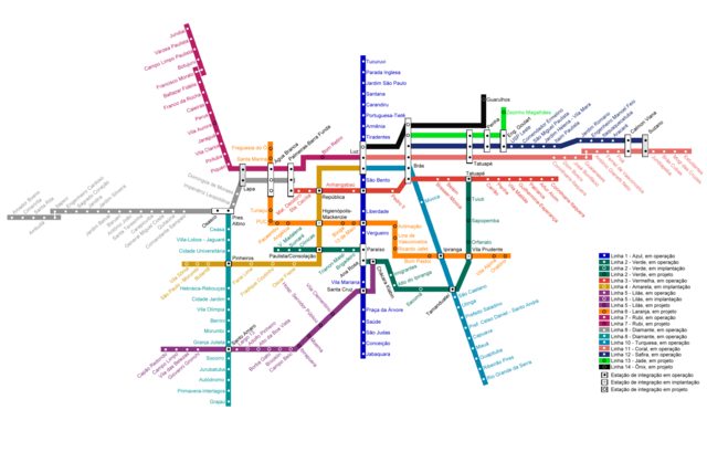
Português: Mapa da Rede Metroferroviária de São Paulo
English: Map of São Paulo metropolitan trains network
|
||
|---|---|---|---|
| Source |
http://www.cptm.sp.gov.br/E_IMAGES/geral/mapa_metropolitano_2804.gif |
||
| Date |
May 15, 2008 |
||
| Author |
Fsolda 19:07, 15 May 2008 (UTC) |
||
| Permission ( Reusing this image) |
|

File history
Click on a date/time to view the file as it appeared at that time.
| Date/Time | Dimensions | User | Comment | |
|---|---|---|---|---|
| current | 19:17, 15 May 2008 | 1,380×881 (253 KB) | Fsolda | |
| 19:07, 15 May 2008 | 1,380×881 (253 KB) | Fsolda | ({{Information |Description={{pt|Mapa da Rede Metroferroviária de São Paulo}} {{en|Map of São Paulo metropolitan trains network}} |Date=May 15, 2008 |Author=~~~~ |Permission={{PD-ineligible}} |other_versions= }} ) |
File links
The following pages on Schools Wikipedia link to this image (list may be incomplete):