From Wikipedia, the free encyclopedia
 Size of this preview: 358 × 479 pixels
 Full resolution (1,584 × 2,121 pixels, file size: 370 KB, MIME type: image/png)
 |
This is a file from the Wikimedia Commons. The description on its description page there is shown below.Commons is a freely licensed media file repository. You can help.
|
 |
This map image should be recreated using vector graphics as an SVG file. This has several advantages; see Commons:Media for cleanup for more information. If an SVG form of this image is already available, please upload it. After uploading an SVG, replace this template with {{ vector version available|new image name.svg}}. |
العربية | Български | Català | Česky | Dansk | Deutsch | English | Esperanto | Español | Français | Galego | 한국어 | Italiano | Magyar | Lietuvių | Nederlands | 日本語 | Polski | Português | Română | Русский | Suomi | Svenska | Türkçe | Українська | 中文(繁體) | 中文(简体) | +/- |
Summary
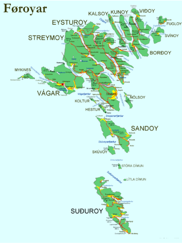
- Map of the Faroe Islands with:
- Cities and villages (yellow fields, including cultivated area). Places with a black dot are abandoned (e.g. Skarð on Kunoy)
- Streets between the places (red lines, if dotted, it's a tunnel.)
- Some major mountains (black triangles with height in metres)
- Ferry harbours (anchor). Note, that the Faroes have many more harbours (almost at each village at the coast). To see the ferry lines, please check the current map here: http://www.ssl.fo/ferdaatlan/images/fkort2004.jpg
- Major firths and straits (blue). Note, that a fjørður in Faroese is not only a firth (fjord) but can also be a strait.
- Major lakes are captioned
- What is missing on this map: Municipality borders, churches, lighthouses, heliports, hospitals, post offices, hotels and camping sites, as well as height lines, but the scale of the map doesn't allow this (IMHO).
- Used sources: http://www.matrikul.fo , http://www.faroestamps.fo , "Turen går til Færøerne" (Politikens Forlag, Copenhagen, 2005), "Føroyar - topografisk kort 1:100.000" (2 parts, Geodætisk Institut, Copenhagen, ca. 1985).
Licensing
I, the copyright holder of this work, hereby publish it under the following licenses:
 |
Permission is granted to copy, distribute and/or modify this document under the terms of the GNU Free Documentation license, Version 1.2 or any later version published by the Free Software Foundation; with no Invariant Sections, no Front-Cover Texts, and no Back-Cover Texts. A copy of the license is included in the section entitled " GNU Free Documentation license".
Aragonés | العربية | Asturianu | Беларуская (тарашкевіца) | Български | বাংলা | ইমার ঠার/বিষ্ণুপ্রিয়া মণিপুরী | Brezhoneg | Bosanski | Català | Cebuano | Česky | Dansk | Deutsch | Ελληνικά | English | Esperanto | Español | Eesti | Euskara | فارسی | Suomi | Français | Gaeilge | Galego | עברית | Hrvatski | Magyar | Bahasa Indonesia | Ido | Íslenska | Italiano | 日本語 | ქართული | ភាសាខ្មែរ | 한국어 | Kurdî / كوردی | Latina | Lëtzebuergesch | Lietuvių | Bahasa Melayu | Nnapulitano | Nederlands | Norsk (nynorsk) | Norsk (bokmål) | Occitan | Polski | Português | Română | Русский | Slovenčina | Slovenščina | Shqip | Српски / Srpski | Svenska | తెలుగు | ไทย | Tagalog | Türkçe | Українська | اردو | Tiếng Việt | Volapük | Yorùbá | 中文(简体) | 中文(繁體) | +/- |
You may select the license of your choice.
|
File history
Click on a date/time to view the file as it appeared at that time.
|
|
Date/Time |
Dimensions |
User |
Comment |
| current |
14:11, 24 September 2005 |
1,584×2,121 (370 KB) |
Arne List |
|
File links
The following pages on Schools Wikipedia link to this image (list may be incomplete):