Image:Antarctica.jpg
From Wikipedia, the free encyclopedia
Size of this preview: 385 × 480 pixels
Full resolution (1,124 × 1,400 pixels, file size: 394 KB, MIME type: image/jpeg)
| |
This is a file from the Wikimedia Commons. The description on its description page there is shown below. |
 A vector version of this image (SVG) is available. For more information about vector graphics, read about Commons transition to SVG. Deutsch | English | Español | Français | Galego | עברית | Magyar | Italiano | 日本語 | 한국어 | Lietuvių | Polski | Português | Русский | Српски / Srpski | Українська | +/- |
 |
Summary
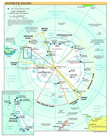
Map of Antarctica from en:Image:Antarctica.jpg
Political map and research stations (2002)
|
This image was (or all images in this article or category were) uploaded in the JPEG format. |
|
Deutsch | English | Español | Français | 日本語 | Português | Русский | +/- |
 |
This image is in the public domain because it contains materials that originally came from the United States Central Intelligence Agency's World Factbook. Deutsch | English | Español | Français | 日本語 | Nederlands | 한국어 | Português | தமிழ் | Magyar | +/- |
 |
(Delete all revisions of this file) (cur) 16:45, 9 September 2005 . . Marknew (Talk) . . 1124x1400 (402970 bytes) (Higher quality and updated image (from PDF).)
(del) (rev) 02:39, 6 February 2005 . . Hfastedge (Talk) . . 990x1220 (210964 bytes) (Reverted to earlier revision)
(del) (rev) 01:58, 6 February 2005 . . DanQuixote (Talk) . . 519x659 (95411 bytes) (Reverted to earlier revision)
(del) (rev) 01:55, 6 February 2005 . . DanQuixote (Talk) . . 990x1220 (210964 bytes) (Antartica political map and research stations (2002))
(del) (rev) 11:49, 20 July 2002 . . . . 519x659 (95411 bytes)
Public domain, produced by the U.S. Central Intelligence Agency.
Larger file available at: The General Libraries, The University of Texas at Austin.
File history
Click on a date/time to view the file as it appeared at that time.
| Date/Time | Dimensions | User | Comment | |
|---|---|---|---|---|
| current | 17:58, 8 January 2006 | 1,124×1,400 (394 KB) | Marknew | (Higher quality and updated image (from PDF).) |
| 00:49, 18 July 2005 | 990×1,220 (206 KB) | Thuresson | (larger) | |
| 21:15, 31 January 2005 | 519×659 (93 KB) | Leonard Vertighel | (Map of Antarctica from en:Image:Antarctica.jpg) |