Image:AntarcticaRockSurface.jpg
From Wikipedia, the free encyclopedia
Size of this preview: 480 × 480 pixels
Full resolution (800 × 800 pixels, file size: 356 KB, MIME type: image/jpeg)
| |
This is a file from the Wikimedia Commons. The description on its description page there is shown below. |
Summary
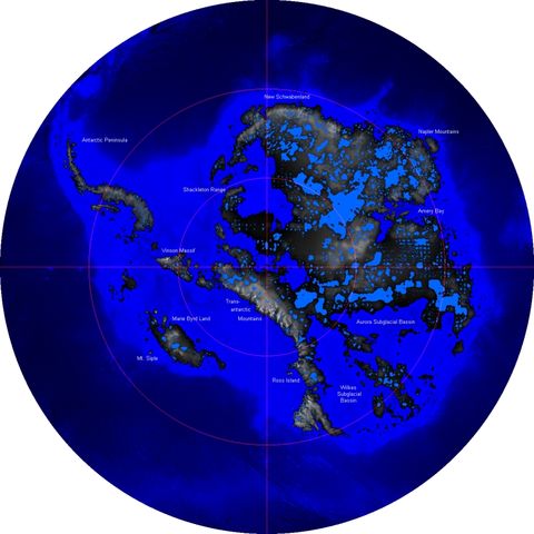
| Description |
Català: L'Antàrtida sense glaç. En aquest mapa no es pren en consideració que el nivell del mar augmentaria degut al desgel. De la mateixa manera, tampoc es considera que la massa geològica també ho faria en uns centenars de metres en un període de desenes de milers d'anys degut a la desaparició de la potent pressió provocada per la immensa capa de glaç.
Deutsch: Antarktika ohne Eis. Berücksichtigt sind hier weder der durch die Eisschmelze bedingte Anstieg des Meeresspiegels noch die langfristige Anhebung der Kontinentalmasse durch das wegfallende Gewicht.
English: Rock surface of Antarctica and sea ground without its ice-shield, from 60 to 90 degrees South. This map does not consider that sea level would rise because of the melted ice, nor that the landmass would rise by several hundred meters over a few tens of thousands of years after the weight of the ice was no longer depressing the landmass.
Polski: Powierzchnia Antarktydy bez lodu. Mapa nie uwzględnia wzrostu poziomu morza po stopieniu lądolodu i następującego, po zniknięciu jego ciężaru, wynurzania się kontynentu
Português: A Antártica sem sua cobertura de gelo, desde 60 até 90 graus de latitude sul. Esse mapa não considera que o nível do mar se elevaria pelo derretimento do gelo, nem que a massa do continente se elevaria em várias centenas de metros num período de algumas dezenas de milhares de anos, ao desaparecer o peso da massa de gelo sobre a rocha.
|
|---|---|
| Source |
Own model based on data provided by BEDMAP Consortium, available at http://www.antarctica.ac.uk/aedc/bedmap/download/ (20 March 2006) |
| Date |
2006-03-20 |
| Author | |
| Permission ( Reusing this image) |
see below
|
Licensing
 |
I, the copyright holder of this work, hereby release it into the public domain. This applies worldwide. In case this is not legally possible: Afrikaans | Alemannisch | Aragonés | العربية | Asturianu | Български | Català | Cebuano | Česky | Cymraeg | Dansk | Deutsch | Eʋegbe | Ελληνικά | English | Español | Esperanto | Euskara | Estremeñu | فارسی | Français | Galego | 한국어 | हिन्दी | Hrvatski | Ido | Bahasa Indonesia | Íslenska | Italiano | עברית | Kurdî / كوردی | Latina | Lietuvių | Latviešu | Magyar | Македонски | Bahasa Melayu | Nederlands | Norsk (bokmål) | Norsk (nynorsk) | 日本語 | Polski | Português | Ripoarisch | Română | Русский | Shqip | Slovenčina | Slovenščina | Српски / Srpski | Suomi | Svenska | ไทย | Tagalog | Türkçe | Українська | Tiếng Việt | Walon | 中文(简体) | 中文(繁體) | zh-yue-hant | +/- |
File history
Click on a date/time to view the file as it appeared at that time.
| Date/Time | Dimensions | User | Comment | |
|---|---|---|---|---|
| current | 10:58, 20 March 2006 | 800×800 (356 KB) | Panda17 | ({{Information| |Description = Rock surface of Antarctica and sea ground, from 60 to 90 degrees South. |Source = Own model based on data provided by BEDMAP Consortium, available at http://www.antarctica.ac.uk/aedc/bedmap/download/ (20 March 2006) |Date = 2) |