Image:Wfm shetland map.png
From Wikipedia, the free encyclopedia
Size of this preview: 365 × 479 pixels
Full resolution (2,000 × 2,624 pixels, file size: 784 KB, MIME type: image/png)
| |
This is a file from the Wikimedia Commons. The description on its description page there is shown below. |
Contents |
Summary
| Description |
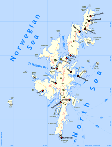
Shetland map |
|---|---|
| Source |
self-made, details of process below |
| Date |
29th August 2005 |
| Author |
Finlay McWalter |
| Permission ( Reusing this image) |
I'm Finlay McWalter, and I endorse this message |
| Other versions | nada |
Method of production
Drawn by Finlay McWalter in the following manner:
- An outline was rendered using Panmap running public domain NOAA WVS (world vector shoreline).
- This was exported (as a bitmap, all that Panmap can do) to Paint Shop Pro. This was manually repaired (holes filled, island groups tweaked, and shoreline details clarified or erased). Then the bitmap was floodfilled, so that the subsequent vectoriser will produce polygons rather than lines.
- This was imported into Inkscape and vectorised using Inkscape's "path->trace bitmap" function.
- All details were then manually drawn.
- To produce the final PNG, the whole drawing was exported from Inkscape as a PNG. This was then cropped in Photoshop.
Version history
- (July 14th 2005) Initial test version
- (August 29th 2005) Added towns, airports, oil terminal. Muckle Roe now correctly rendered as a separate island.
- (August 29th 2005) Swapped locations of Sumburgh town and Sumburgh Airport, PNGcrushed image.
Licensing
|

File history
Click on a date/time to view the file as it appeared at that time.
| Date/Time | Dimensions | User | Comment | |
|---|---|---|---|---|
| current | 19:18, 29 August 2005 | 2,000×2,624 (784 KB) | Finlay McWalter | (Swapped locations of Sumburgh town and Sumburgh Airport, PNGcrushed image) |
| 18:23, 29 August 2005 | 2,019×2,659 (1.13 MB) | Finlay McWalter | ( {{Information| |Description = en:Shetland map |Source = self-made, details of process below |Date = 29th August 2005 |Author = Finlay McWalter |Permission = I'm Finlay McWalter, and I endorse this message |other_version) |