Image:Map Cymru 1996 gyda rhifau.svg
From Wikipedia, the free encyclopedia
Map_Cymru_1996_gyda_rhifau.svg (SVG file, nominally 500 × 621 pixels, file size: 50 KB)
| |
This is a file from the Wikimedia Commons. The description on its description page there is shown below. |
This version has all the extra SVG-cruft removed, all counties in separate groups, and the "id" field of each group set to the Welsh name of each county rather than a number.
| Description |
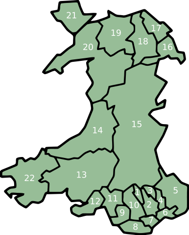
Same as Image:Map Cymru 1996 heb enwau.svg, but the numbers from Image:WalesNumbered.png have been added back. |
|---|---|
| Source |
Image:WalesNumbered.png + GIMP + VectorMagic + Inkscape + emacs |
| Date | |
| Author |
User:Marnanel, after en:User:Morwen |
| Permission ( Reusing this image) |
GFDL |
| Other versions | Image:WalesNumbered.png |
Licensing
 |
Permission is granted to copy, distribute and/or modify this document under the terms of the GNU Free Documentation License, Version 1.2 or any later version published by the Free Software Foundation; with no Invariant Sections, no Front-Cover Texts, and no Back-Cover Texts. Subject to disclaimers. Asturianu | Български | Català | Deutsch | English | Español | Français | Gaeilge | Italiano | Polski | Português | +/- |
Legend
- Merthyr Tydfil/Merthyr Tudful
- Caerphilly/Caerffili
- Blaenau Gwent
- Torfaen/Tor-faen
- Monmouthshire/Sir Fynwy
- Newport/Casnewydd
- Cardiff/Caerdydd
- Vale of Glamorgan/Bro Morgannwg
- Bridgend/Pen-y-bont ar Ogwr
- Rhondda Cynon Taff/Rhondda Cynon Tâf
- Neath Port Talbot/Castell-nedd Port Talbot
- Swansea/Abertawe
- Carmarthenshire/Sir Gaerfyrddin
- Ceredigion
- Powys
- Wrexham/Wrecsam
- Flintshire/Sir y Fflint
- Denbighshire/Sir Ddinbych
- Conwy
- Gwynedd
- Isle of Anglesey/Ynys Môn
- Pembrokeshire/Sir Benfro
File history
Click on a date/time to view the file as it appeared at that time.
| Date/Time | Dimensions | User | Comment | |
|---|---|---|---|---|
| current | 02:06, 12 February 2008 | 500×621 (50 KB) | Marnanel | (This version has all the extra SVG-cruft removed, all counties in separate groups, and the "id" field of each group set to the Welsh name of each county rather than a number. {{Information |Description=Same as Image:Map Cymru 1996 heb enwau.svg, but) |
File links
The following pages on Schools Wikipedia link to this image (list may be incomplete):