Image:5 Boroughs Labels New York City Map Julius Schorzman.png
From Wikipedia, the free encyclopedia
Size of this preview: 493 × 480 pixels
Full resolution (2,652 × 2,582 pixels, file size: 6.5 MB, MIME type: image/png)
| |
This is a file from the Wikimedia Commons. The description on its description page there is shown below. |
Summary
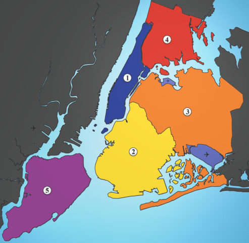
| Description |
A map showing the five boroughs of New York City, as well as airports. Airports: North East: LGA; South East: JFK; West: EWR |
|---|---|
| Source |
I created this image using various maps and images. |
| Date |
2005-08-18 |
| Author |
Julius Schorzman |
| Permission ( Reusing this image) |
see below
|
Licensing
| |
This file is licensed under the Creative Commons Attribution ShareAlike 2.5 License. In short: you are free to share and make derivative works of the file under the conditions that you appropriately attribute it, and that you distribute it only under a license identical to this one. Official license |
File history
Click on a date/time to view the file as it appeared at that time.
| Date/Time | Dimensions | User | Comment | |
|---|---|---|---|---|
| current | 02:21, 19 August 2005 | 2,652×2,582 (6.5 MB) | Quasipalm | (A map showing the five boroughs of New York City, as well as airports. # Manhattan # Brooklyn # Queens # Bronx # Staten Island Airports: Nort East: LGA Sout East: JFK West: EWR Source: I created this image using various maps and images. {{cc-by-sa-2.5}) |
File links
The following pages on Schools Wikipedia link to this image (list may be incomplete):