Image:Aster newyorkcity lrg.jpg
From Wikipedia, the free encyclopedia
Size of this preview: 361 × 479 pixels
Full resolution (1,964 × 2,607 pixels, file size: 3.31 MB, MIME type: image/jpeg)
| |
This is a file from the Wikimedia Commons. The description on its description page there is shown below. |
| Description |
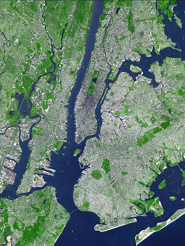
This false-colour satellite image shows Greater New York City. The Island of Manhattan juts southward from top centre, bordered by the Hudson River to the west and the East River to the east (north is straight up in this scene.) In the middle of Manhattan, Central Park appears as a long green rectangle running roughly north-south with a large lake in the middle. The large land mass east of Manhattan is the western end of Long Island, which is comprised of the boroughs of Queens and Brooklyn and two counties, Nassau and Suffolk (not shown) which are not part of New York City. Parts of Staten Island (bottom left corner) and Breezy Point-Rockaway Beach (lower right)are also visible. Source: http://earthobservatory.nasa.gov/Newsroom/NewImages/Images/aster_newyorkcity_lrg.jpg This false-colour image was acquired on Sept. 8, 2002, by the Advanced Spaceborne Thermal Emission and Reflection Radiometer (ASTER) aboard NASA's Terra satellite. The scene spans an area that is 27 km wide by 37 km tall. Vegetated land surface is green, paved urban areas are a whitish blue, and water is dark blue. |
|---|---|
| Source |
Originally from en.wikipedia; description page is/was here. |
| Date |
2006-08-17 (original upload date) |
| Author |
Original uploader was AAK at en.wikipedia |
| Permission ( Reusing this image) |
PD-LAYOUT; PD-USGOV-NASA.
|
License information
 |
This file is in the public domain because it was created by NASA. NASA copyright policy states that "NASA material is not protected by copyright unless noted". ( NASA copyright policy page or JPL Image Use Policy). Deutsch | English | Español | Français | Galego | Nederlands | Português | Русский | 中文(简体) | 中文(繁體) | +/- |
|
 |
Warnings:
|
Original upload log
(All user names refer to en.wikipedia)
- 2006-08-17 19:41 AAK 1964×2607×8 (3471119 bytes) This false-color satellite image shows Greater New York City. The Island of Manhattan juts southward from top centre, bordered by the Hudson River to the west and the East River to the east (north is straight up in this scene.) In the middle of Manhattan
File history
Click on a date/time to view the file as it appeared at that time.
| Date/Time | Dimensions | User | Comment | |
|---|---|---|---|---|
| current | 18:54, 8 August 2007 | 1,964×2,607 (3.31 MB) | HenrikRomby | ({{Information |Description=This false-color satellite image shows Greater New York City. The Island of Manhattan juts southward from top centre, bordered by the Hudson River to the west and the East River to the east (north is straight up in this scene.)) |
File links
Metadata
This file contains additional information, probably added from the digital camera or scanner used to create or digitize it. If the file has been modified from its original state, some details may not fully reflect the modified file.
| Orientation | Normal |
|---|---|
| Horizontal resolution | 100 dpi |
| Vertical resolution | 100 dpi |
| Software used | Adobe Photoshop 7.0 |
| File change date and time | 17:01, 1 August 2003 |
| Colour space | 65535 |