Image:Indus.A2002274.0610.1km.jpg
From Wikipedia, the free encyclopedia
Size of this preview: 367 × 480 pixels
Full resolution (1,300 × 1,700 pixels, file size: 480 KB, MIME type: image/jpeg)
 |
This is a candidate to be copied to the Wikimedia Commons. Appropriately licensed media are more accessible to other Wikimedia projects if placed on Commons. Any user may perform this move - please see Moving images to the Commons for more information. Please remove this tag after this image has been copied to Commons. Copy to Commons via CommonsHelper |
 |
This file is in the public domain because it was created by NASA. NASA copyright policy states that "NASA material is not protected by copyright unless noted". ( NASA copyright policy page or JPL Image Use Policy)
|
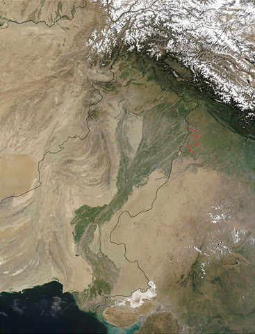
Satellite image of the Indus River basin. Red dots indicate fires. International boundaries are superimposed; the boundary through Jammu and Kashmir reflects the Line of Control.
| |
This file is an exact duplicate of another file from the Wikimedia Commons. Unless it is currently protected from editing, this media file may qualify for speedy deletion if it satisfies these conditions. | |
File history
Click on a date/time to view the file as it appeared at that time.
| Date/Time | Dimensions | User | Comment | |
|---|---|---|---|---|
| current | 16:29, 16 August 2005 | 1,300×1,700 (480 KB) | Tom Radulovich ( Talk | contribs) | ({{PD-USGov-NASA}}) |
See the setup instructions for more information.
File links
The following file is a duplicate of this file:
The following pages on Schools Wikipedia link to this image (list may be incomplete):
Categories: Copy to Wikimedia Commons | NASA images