Image:Mt Vesuvius 79 AD eruption 3.svg
From Wikipedia, the free encyclopedia
Mt_Vesuvius_79_AD_eruption_3.svg (SVG file, nominally 652 × 396 pixels, file size: 113 KB)
| |
This is a file from the Wikimedia Commons. The description on its description page there is shown below. |
Contents |
Summary
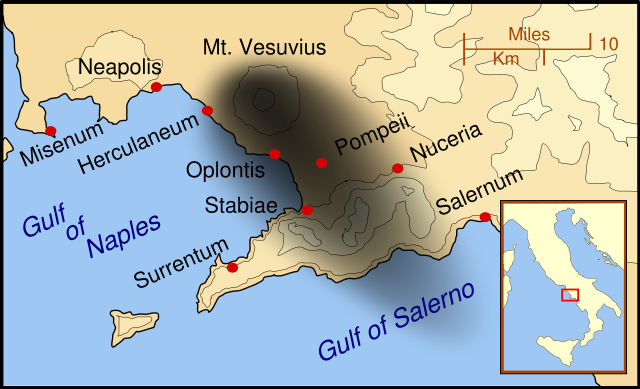
| Description |
A map showing the cities and towns affected by the eruption of Mount Vesuvius in 79 AD. The general shape of the ash and cinder fall (see w:en:pyroclast) is shown by the dark area to the southeast of Mt Vesuvius. (P.S. It seems strange to show the modern day English names for the two bodies of water - I am open to suggestions). This map shows present day coast lines and uses the Mercator projection (although that is not important on a map of this scale). North is, as usual, at the top of the map. |
|---|---|
| Source |
self-made |
| Date |
October 2007 |
| Author |
MapMaster |
| Permission ( Reusing this image) |
see below
|
References
This map is intended to show the general distribution of (airborne) ash punice, and other particles. I built the map from descriptions of the event as well as these maps:
- Luongo, Giuseppe; Perrotta, Annamaria; Scarpati, Claudio;De Carolis, Ernesto;Patricelli, Giovanni;Ciarallo, Annamaria (2003) " Impact of the AD 79 explosive eruption on Pompeii" in Journal of Volcanology and Geothermal Research v126 pp. 169-200.
Other versions
- English
Licensing
|

File history
Click on a date/time to view the file as it appeared at that time.
| Date/Time | Dimensions | User | Comment | |
|---|---|---|---|---|
| current | 01:07, 16 October 2007 | 652×396 (113 KB) | MapMaster | (corrected mis-named Gulf of Salerno) |
| 04:02, 15 October 2007 | 652×396 (112 KB) | MapMaster | (Dropped Title sqaure, and added towns and names of the 2 bays.) | |
| 05:16, 14 October 2007 | 652×454 (126 KB) | MapMaster | (Minor changes made after seeing how it's rendered by Wikimedia) | |
| 05:11, 14 October 2007 | 355×247 (125 KB) | MapMaster | ({{Information |Description=A map showing the cities and town affected by the eruption of Mount Vesuvius in 79 AD. The general shape of the ash and cinder fall is shown by the dark area to the southeast of Mt Vesuvious. |Source=self-made |Date=October 200) |