Image:Mwamongu water source.jpg
From Wikipedia, the free encyclopedia
Size of this preview: 591 × 480 pixels
Full resolution (946 × 768 pixels, file size: 344 KB, MIME type: image/jpeg)
| |
This is a file from the Wikimedia Commons. The description on its description page there is shown below. |
| Description |
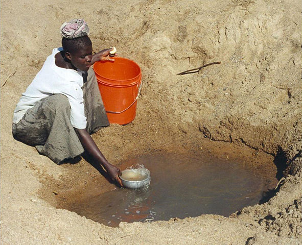
Mwamanongu Village water source, Tanzania. "In Meatu district, Shinyanga region, Tanzania, water most often comes from open holes dug in the sand of dry riverbeds, and it is invariably contaminated." |
||
|---|---|---|---|
| Source |
http://solarcooking.wikia.com/wiki/Image:Mwamongu_water_source.jpg, http://imageevent.com/bobmetcalf/watertestingpasteurizationinafrica |
||
| Date |
2006-06-06 |
||
| Author |
Bob Metcalf |
||
| Permission ( Reusing this image) |
|

| Camera location |
|
See this image at its location on Google Maps This location on: Live Maps - Trails.com - TerraServer-USA |
|---|
Location note from author: If one goes north from the city of Tabora, follow it to Shinyanga. Shinyanga town is the administrative location of the Shinyanga Region, which includes several districts, Meatu District being one of them. From Shinyanga, go east to find the town of Mhunze, which I think is what I know as Mwanhuze, the District headquarters. It was from Mhunze that we took a Land Rover a bit northwest, I think, perhaps 15 km, to reach Mwamanongu. The driver knew how to get to these villages, but there were no road signs anywhere, nor any landmarks on the flat land, and the 'road' was just a path, often in lousy condition for the rare vehicle that would use it.
Editor's note: Mwanhuze and Mwamanongu are wards in en:Meatu District. Meatu is a trapezoidal region that borders the western end of Lake Eyasi and extends roughly 70 km to the northwest. Mhunze is a ward in en:Bariadi District. Walter Siegmund (talk) 05:02, 14 January 2008 (UTC)
 |
This is a valued image on Wikimedia Commons. The image has been assessed under the valued image criteria and is considered the most valued image on Commons within the scope: Primitive water supply. You can see its nomination at Commons:Valued image candidates/Mwamongu water source.jpg. |
File history
Click on a date/time to view the file as it appeared at that time.
| Date/Time | Dimensions | User | Comment | |
|---|---|---|---|---|
| current | 23:39, 12 January 2008 | 946×768 (344 KB) | Wsiegmund | (PE; cropped white borders) |
| 23:38, 12 January 2008 | 1,024×768 (149 KB) | Wsiegmund | (Upload slightly larger version) | |
| 14:58, 12 January 2008 | 944×704 (85 KB) | Wsiegmund | ({{Information |Description=Mwamongu Village water source, Tanzania |Source= Wikia:c:solarcooking:Image:Mwamongu_water_source.jpg |Date=2006-06-06 |Author=Bob Metcalf |Permission={{PD-author|Bob Metcalf}} |other_versions= }} ) |
File links
Metadata
This file contains additional information, probably added from the digital camera or scanner used to create or digitize it. If the file has been modified from its original state, some details may not fully reflect the modified file.
| Orientation | Normal |
|---|---|
| Horizontal resolution | 72 dpi |
| Vertical resolution | 72 dpi |
| Software used | Adobe Photoshop Elements 4.0.1 Macintosh |
| File change date and time | 14:06, 12 January 2008 |
| Colour space | sRGB |