Image:Northern Ireland map - July 2007.png
From Wikipedia, the free encyclopedia
Size of this preview: 640 × 461 pixels
Full resolution (775 × 558 pixels, file size: 374 KB, MIME type: image/png)
Summary
| |
This map image was uploaded in a raster image format such as PNG, GIF, or JPEG. However, it contains information that could be stored more efficiently and/or accurately in the SVG format, as a vector graphic. If possible, please upload an SVG version of this image. After doing so, please replace all instances of the previous version throughout Wikipedia (noted under the “File links” header), tag the old version with {{ Vector version available|NewImage.svg}}, and remove this tag. For more information, see Wikipedia:Preparing images for upload. For assistance with converting to SVG, please see the Graphics Lab. |
 |
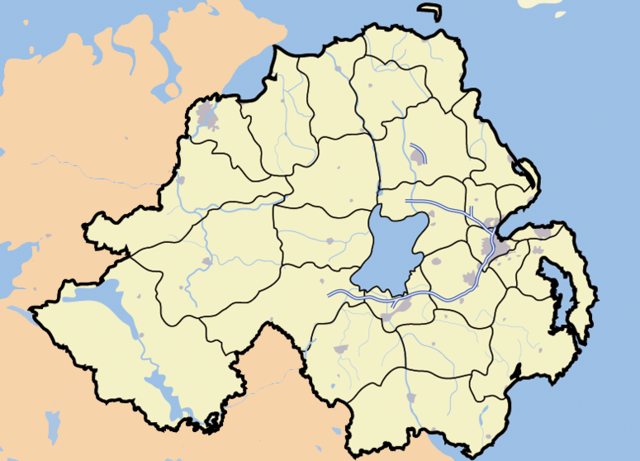
Map of Northern Ireland, and surrounding seas and territory. Features built-up areas in grey, water in light-blue, and motorways in blue with white stripe. Districts of Northern Ireland are marked in black.
Licensing
 |
I, the copyright holder of this work, hereby release it into the public domain. This applies worldwide. In case this is not legally possible, |
| |
This file is an exact duplicate of another file from the Wikimedia Commons. Unless it is currently protected from editing, this media file may qualify for speedy deletion if it satisfies these conditions. | |
File history
Click on a date/time to view the file as it appeared at that time.
| Date/Time | Dimensions | User | Comment | |
|---|---|---|---|---|
| current | 14:44, 9 July 2008 | 775×558 (374 KB) | Crazy Among ( Talk | contribs) | (Reverted to version as of 14:41, 14 August 2007) |
| revert | 17:00, 7 July 2008 | 775×558 (357 KB) | Niall1990 ( Talk | contribs) | ({{Information |Description= Northern Ireland map showing Carnmomney |Source=I created this work entirely by myself. |Date= 7/7/08 |Author= ND |other_versions= }}) |
| revert | 14:41, 14 August 2007 | 775×558 (374 KB) | Jza84 ( Talk | contribs) | (adding boundary between Belfast and North Down) |
| revert | 20:09, 5 July 2007 | 775×558 (374 KB) | Jza84 ( Talk | contribs) | (correcting the colour of Kintyre as part of UK.) |
| revert | 00:03, 4 July 2007 | 775×558 (374 KB) | Jza84 ( Talk | contribs) | (Map of Northern Ireland, and surrounding seas and territory. Features built-up areas in grey, water in light-blue, and motorways in blue with white stripe. Districts of Northern Ireland are marked in black. ) |
See the setup instructions for more information.
File links
The following file is a duplicate of this file:
The following pages on Schools Wikipedia link to this image (list may be incomplete):
Categories: Map images that should be in SVG format | User-created public domain images