Image:NASA ASMR-E image of average SSTs of Hurricane Katrina.jpg
From Wikipedia, the free encyclopedia
Size of this preview: 600 × 480 pixels
Full resolution (720 × 576 pixels, file size: 467 KB, MIME type: image/jpeg)
| |
This is a file from the Wikimedia Commons. The description on its description page there is shown below. |
| Description |
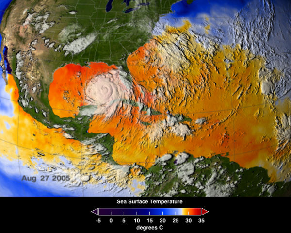
An average of actual sea surface temperatures (SSTs) for the Caribbean Sea and Atlantic Ocean, spanning August 25 to August 27, 2005. Every area in yellow, orange or red represents 82 degrees Fahrenheit or above. SSTs at or above 82 degrees will allow hurricanes to strengthen. The data came from the Advanced Microwave Scanning Radiometer (AMSR-E) instrument on NASA's Aqua satellite. Original image location at http://www.nasa.gov/images/content/126421main_image_feature_398a_ys_full.jpg; there is also an animation of the SSTs of that region between June and September at http://www.nasa.gov/vision/earth/lookingatearth/hurricane_record.html. |
|||
|---|---|---|---|---|
| Source |
http://www.nasa.gov/images/content/126421main_image_feature_398a_ys_full.jpg |
|||
| Date | ||||
| Author |
User Janet13 on en.wikipedia |
|||
| Permission ( Reusing this image) |
|
|||
| Other versions |
Originally from en.wikipedia; description page is (was) here * 06:20, 8 September 2005 [[:en:User:Janet13|Janet13]] 720×576 (477,779 bytes) <span class="comment">(An average of actual sea surface temperatures (SSTs) for the Caribbean Sea and Atlantic Ocean, spanning August 25 to August 27, 2005. Every area in yellow, orange or red represents 82 degrees Fahrenheit or above. SSTs at or above 82 degress will allow hur)</span> |


File history
Click on a date/time to view the file as it appeared at that time.
| Date/Time | Dimensions | User | Comment | |
|---|---|---|---|---|
| current | 14:29, 14 August 2006 | 720×576 (467 KB) | Nilfanion | ({{Information| |Description= An average of actual sea surface temperatures (SSTs) for the Caribbean Sea and Atlantic Ocean, spanning August 25 to August 27, 2005. Every area in yellow, orange or red represents 82 degrees Fahrenheit or above. SSTs at or a) |
File links
Metadata
This file contains additional information, probably added from the digital camera or scanner used to create or digitize it. If the file has been modified from its original state, some details may not fully reflect the modified file.
| Orientation | Normal |
|---|---|
| Horizontal resolution | 72 dpi |
| Vertical resolution | 72 dpi |
| Software used | Adobe Photoshop CS Windows |
| File change date and time | 09:59, 30 August 2005 |
| Colour space | 65535 |