Image:US Secession map 1865.svg
From Wikipedia, the free encyclopedia
US_Secession_map_1865.svg (SVG file, nominally 927 × 588 pixels, file size: 233 KB)
| |
This is a file from the Wikimedia Commons. The description on its description page there is shown below. |
| Description |
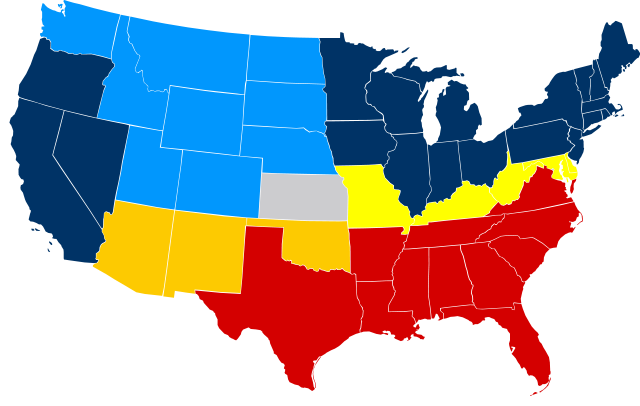
United States map of 1865, show affiliation of states and territories regarding the Secession War (Civil War.) Legend: ██ Union states ██ Union territories not permitting slavery ██ Border Union states, permitting slavery ██ Bleeding Kansas, entered Union ██ Confederate states ██ Union territories permitting slavery |
|||||
|---|---|---|---|---|---|---|
| Source |
|
|||||
| Date |
23 February 2007 |
|||||
| Author |
Júlio Reis |
|||||
| Permission ( Reusing this image) |
See below.
|


| |
This file is licensed under the Creative Commons Attribution ShareAlike 2.5 License. In short: you are free to share and make derivative works of the file under the conditions that you appropriately attribute it, and that you distribute it only under a license identical to this one. Official license |
File history
Click on a date/time to view the file as it appeared at that time.
| Date/Time | Dimensions | User | Comment | |
|---|---|---|---|---|
| current | 09:50, 6 March 2008 | 927×588 (233 KB) | Escondites | ({{Information |Description= |Source= |Date= |Author= |Permission= |other_versions= }} ) |
| 19:14, 26 June 2007 | 882×553 (102 KB) | Nostrifikator | ({{Tintazul |Description=United States map of 1865, show affiliation of states and territories regarding the Secession War (Civil War.) Legend: {{legend|#204A87|Union states}} {{legend|#729FCF|Union territories}} {{legend|#EDD400|Border Union states, permi) | |
| 17:10, 23 February 2007 | 882×553 (102 KB) | Tintazul | ({{Tintazul |Description=United States map of 1865, show affiliation of states and territories regarding the Secession War (Civil War.) Legend: {{legend|#204A87|Union states}} {{legend|#729FCF|Union territories}} {{legend|#EDD400|Border Union states, permi) |
File links
The following pages on Schools Wikipedia link to this image (list may be incomplete):