Image:Rhein-Karte.png
From Wikipedia, the free encyclopedia
Size of this preview: 342 × 480 pixels
Full resolution (794 × 1,114 pixels, file size: 84 KB, MIME type: image/png)
| |
This is a file from the Wikimedia Commons. The description on its description page there is shown below. |
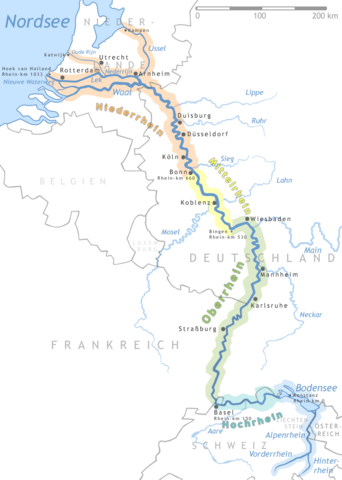
Map of the Rhine
- The map shows the river Rhine
- "drawn" by myself, Daniel Ullrich (Threedots) with Adobe Photoshop 6.0 in January 2005
- If you ask for, I will give you the .psd- / .xfc-file or I'll correct it or create another language version
Karte des Rhein
- Die Karte zeigt den Fluss Rhein
- von mir selbst, Daniel Ullrich (Threedots) im Januar 2005 mit Adobe Photoshop 6.0 "gezeichnet"
- Auf Anfrage stelle ich gern die .psd- / .xfc-Datei bereit oder erstelle selbst korrigierte oder andersprachige Versionen
|

 |
This map image should be recreated using vector graphics as an SVG file. This has several advantages; see Commons:Media for cleanup for more information. If an SVG form of this image is already available, please upload it. After uploading an SVG, replace this template with {{ vector version available|new image name.svg}}. |
|
العربية | Български | Català | Česky | Dansk | Deutsch | English | Esperanto | Español | Français | Galego | 한국어 | Italiano | Magyar | Lietuvių | Nederlands | 日本語 | Polski | Português | Română | Русский | Suomi | Svenska | Türkçe | Українська | 中文(繁體) | 中文(简体) | +/- |
|
File history
Click on a date/time to view the file as it appeared at that time.
| Date/Time | Dimensions | User | Comment | |
|---|---|---|---|---|
| current | 16:18, 7 February 2005 | 794×1,114 (84 KB) | Threedots | (more tiny fixes) |
| 15:56, 7 February 2005 | 794×1,114 (84 KB) | Threedots | (some fixes (more cities, km-data, thinner borders, colour changes...)) | |
| 13:56, 31 January 2005 | 794×1,114 (82 KB) | Threedots | (tiny corections in delta region) | |
| 03:46, 28 January 2005 | 794×1,114 (82 KB) | Threedots | (Map of the river Rhine {{GFDL}}) |