Image:Crusade of 1101 v1.svg

From Wikipedia, the free encyclopedia

Crusade_of_1101_v1.svg‎ (SVG file, nominally 1,039 × 726 pixels, file size: 450 KB)

Wikimedia Commons logo This is a file from the Wikimedia Commons. The description on its description page there is shown below.
Commons is a freely licensed media file repository. You can help.

Contents

Summary

Description

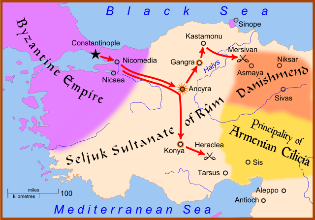
A map showing the movements of Christian armies in Anatolia during the Crusade of 1101.

This map uses Image:Anatolia 1097.svg as a base map. The star at Ancyra indicates that the city was taken by the Crusaders. A circle around a city, as at Konya and Gangra, indicates that the city was placed under siege but was not taken.

Source

self-made

Date

27 Feb 2008

Author

MapMaster

Permission
( Reusing this image)

see below


Other versions

English Italiano


References

  • Hammond World Atlas Corporation (2007) Historical World Atlas, ISBN 9-780843-71391-6
  • Fisher, Sydney Nettleton (2000). The Foreign Relations of Turkey 1481-1512. Electronic Journal of Oriental Studies.
  • Runciman, Steven, A History of the Crusades, vol. 2: The Kingdom of Jerusalem and the Frankish East, 1100-1187, Cambridge University Press, 1951.

Licensing

I, the copyright holder of this work, hereby publish it under the following licenses:
GNU head Permission is granted to copy, distribute and/or modify this document under the terms of the GNU Free Documentation license, Version 1.2 or any later version published by the Free Software Foundation; with no Invariant Sections, no Front-Cover Texts, and no Back-Cover Texts. A copy of the license is included in the section entitled " GNU Free Documentation license".

Aragonés | العربية | Asturianu | Беларуская (тарашкевіца) | Български | বাংলা | ইমার ঠার/বিষ্ণুপ্রিয়া মণিপুরী | Brezhoneg | Bosanski | Català | Cebuano | Česky | Dansk | Deutsch | Ελληνικά | English | Esperanto | Español | Eesti | Euskara | فارسی | Suomi | Français | Gaeilge | Galego | עברית | Hrvatski | Magyar | Bahasa Indonesia | Ido | Íslenska | Italiano | 日本語 | ქართული | ភាសាខ្មែរ | 한국어 | Kurdî / كوردی | Latina | Lëtzebuergesch | Lietuvių | Bahasa Melayu | Nnapulitano | Nederlands | ‪Norsk (nynorsk)‬ | ‪Norsk (bokmål)‬ | Occitan | Polski | Português | Română | Русский | Slovenčina | Slovenščina | Shqip | Српски / Srpski | Svenska | తెలుగు | ไทย | Tagalog | Türkçe | Українська | اردو | Tiếng Việt | Volapük | Yorùbá | ‪中文(简体)‬ | ‪中文(繁體)‬ | +/-

Some rights reserved
Creative Commons Attribution icon Creative Commons Share Alike icon
This file is licensed under the Creative Commons Attribution ShareAlike license versions 3.0, 2.5, 2.0, and 1.0

Български | Català | Česky | Dansk | Deutsch | Ελληνικά | English | Español | Euskara | Estremeñu | Français | עברית | Italiano | 日本語 | 한국어 | Lietuvių | Nederlands | ‪Norsk (bokmål)‬  | Occitan | Polski | Piemontèis | Português | Русский | 中文 | +/-

You may select the license of your choice.

File history

Click on a date/time to view the file as it appeared at that time.

Date/Time Dimensions User Comment
current 16:16, 28 February 2008 1,039×726 (450 KB) MapMaster (Not Mervisan, but Mersivan)
22:04, 27 February 2008 1,039×726 (457 KB) MapMaster ({{Information |Description=A map showing the movements of Christian armies in Anatolia during the Crusade of 1101 |Source=self-made |Date=27 Feb 2008 |Author= MapMaster |Permission= |other_ver)
The following pages on Schools Wikipedia link to this image (list may be incomplete):
This Wikipedia DVD Selection has a sponsor: SOS Children , and is a hand-chosen selection of article versions from the English Wikipedia edited only by deletion (see www.wikipedia.org for details of authors and sources). See also our Disclaimer.