Image:K-T boundary.jpg
From Wikipedia, the free encyclopedia
Size of this preview: 640 × 407 pixels
Full resolution (720 × 458 pixels, file size: 322 KB, MIME type: image/jpeg)
| |
This is a file from the Wikimedia Commons. The description on its description page there is shown below. |
| Description |
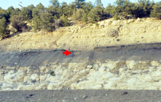
English: K-T boundary (red arrow) along Interstate 25, Raton Pass, Colorado
Deutsch: KT-Grenze (Roter Pfeil) entlang der Interstate 25, Raton Pass, Colorado
|
|---|---|
| Source |
self-made by Ank-man, first upload here |
| Date |
April, 1992 |
| Author |
Anky-man at en.wikipedia |
| Permission ( Reusing this image) |
see below
|
License information
|

Original upload log
(All user names refer to en.wikipedia)
- 2007-04-16 16:35 Anky-man 720×458×8 (329312 bytes) {{Information| |Description =K-T boundary (red arrow) along Interstate 25, Raton Pass, Colorado |Source = self-made by Ank-man |Date = April, 1992 |Author = ~~~~ |Permission = I grant use of this image. }}
[[Category:K/T Event]
File history
Click on a date/time to view the file as it appeared at that time.
| Date/Time | Dimensions | User | Comment | |
|---|---|---|---|---|
| current | 20:21, 21 September 2007 | 720×458 (322 KB) | Polarlys | ({{Information |Description={{en|K-T boundary (red arrow) along Interstate 25, Raton Pass, Colorado}} |Source=self-made by Ank-man, first upload [http://en.wikipedia.org/w/index.php?title=Image%3AK-T_boundary.jpg here] |Date=April, 1992 |Author=[[:en:User:) |