Image:Sokhta Koh.jpg
From Wikipedia, the free encyclopedia
Size of this preview: 635 × 480 pixels
Full resolution (650 × 491 pixels, file size: 91 KB, MIME type: image/jpeg)
Summary
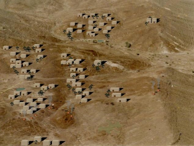
Picture of Sokhta Koh, a Harappan coastal settlement. Picture, along with computer-aided reconstruction by Kaiser Tufail. Picture taken from aircraft from an altitude of 1,500' AGL in 1993. Sokhta Koh means 'burnt hill' as is evident from browned-out earth due to extensive firing of pottery in open pit ovens. All houses/huts, open pit ovens and some shrubbery based on computer-aided art. Houses/huts numbering 78, are exactly overlaid on the visible foundations.
airknight_kt@yahoo.com
Licensing
|
lflflyfly
File history
Click on a date/time to view the file as it appeared at that time.
| Date/Time | Dimensions | User | Comment | |
|---|---|---|---|---|
| current | 09:06, 7 October 2006 | 650×491 (91 KB) | R2j2 ( Talk | contribs) | (Picture of Sokhta Koh, a Harappan coastal settlement. Picture alongwith computer-aided reconstruction by Kaiser Tufail. Picture taken from aircraft in 1993.) |
See the setup instructions for more information.
File links
The following pages on Schools Wikipedia link to this image (list may be incomplete):
Categories: Creative Commons Attribution 2.5 images | Self-published work