Image:Flores map.png
From Wikipedia, the free encyclopedia
No higher resolution available.
Flores_map.png (300 × 122 pixels, file size: 21 KB, MIME type: image/png)
| |
This is a file from the Wikimedia Commons. The description on its description page there is shown below. |
This image was copied from wikipedia:en. The original description was:
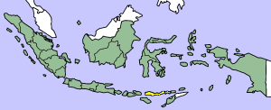
Map showing Flores Island within Indonesia
| |
This file has been released into the public domain by the copyright holder, its copyright has expired, or it is ineligible for copyright. This applies worldwide. |
| |
Note: This tag is obsolete! Nothing is public domain without a reason. Don't use this generic template - please use instead:
العربية | Български | Česky | Deutsch | English | Español | Français | हिन्दी | Italiano | 日本語 | Norsk (bokmål) | Norsk (nynorsk) | Polski | Português | Русский | Slovenčina | Slovenščina | Српски / Srpski | Türkçe | 中文 | +/- |
| date/time | username | edit summary |
|---|---|---|
| 14:17, 14 March 2005 | *drew | (Map showing Flores Island within Indonesia {{PD}}) |
File history
Click on a date/time to view the file as it appeared at that time.
| Date/Time | Dimensions | User | Comment | |
|---|---|---|---|---|
| current | 10:19, 2 February 2007 | 300×122 (21 KB) | J. Patrick Fischer | (The original image was copied from wikipedia:en. The image was corrected by user:J. Patrick Fischer (two islands east of Flores were wrong marked as part of Flores before). The original description was: Map showing Flores Island within Indonesia {{) |
| 12:26, 10 October 2006 | 300×122 (16 KB) | UtherSRG | (Change colour.) | |
| 12:27, 5 October 2005 | 300×122 (15 KB) | ChongDae | (This image was copied from wikipedia:en. The original description was: Map showing Flores Island within Indonesia {{PD}} {| border="1" ! date/time || username || edit summary |---- | 14:17, 14 March 2005 || *drew || <nowiki>(Map showing Flores Island wi) |
File links
The following pages on Schools Wikipedia link to this image (list may be incomplete):