Image:Map of the River Thames downstream from London 1840.JPG
From Wikipedia, the free encyclopedia
Size of this preview: 640 × 321 pixels
Full resolution (906 × 454 pixels, file size: 165 KB, MIME type: image/jpeg)
| |
This is a file from the Wikimedia Commons. The description on its description page there is shown below. |
| Description |
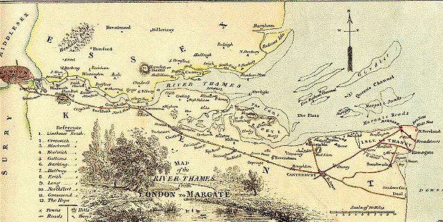
A map of the lower Thames in 1840. |
||
|---|---|---|---|
| Source | |||
| Date |
Uploaded to Commons 2006-11-12 |
||
| Author |
User Gillian Tipson on en.wikipedia |
||
| Permission ( Reusing this image) |
|
||
| Other versions |
Originally from en.wikipedia; description page is (was) here * 09:58, 13 May 2005 [[:en:User:Gillian Tipson|Gillian Tipson]] 906×454 (169,312 bytes) <span class="comment">(A map of the lower Thames in 1840. {{PD}})</span> |

(Uploaded using CommonsHelper or PushForCommons)
File history
Click on a date/time to view the file as it appeared at that time.
| Date/Time | Dimensions | User | Comment | |
|---|---|---|---|---|
| current | 14:40, 12 November 2006 | 906×454 (165 KB) | JackyR | ({{Information| |Description= A map of the lower Thames in 1840. |Source= |Date=Uploaded to Commons 2006-11-12 |Author=User Gillian Tipson on [http://en.wikipedia.org en.wikipedia] |Permission={{PD-old}} |other_versions= Origina) |