Image:Isle of Man map-en.svg
From Wikipedia, the free encyclopedia
Isle_of_Man_map-en.svg (SVG file, nominally 1,200 × 1,100 pixels, file size: 786 KB)
| |
This is a file from the Wikimedia Commons. The description on its description page there is shown below. |
Summary
| Description |
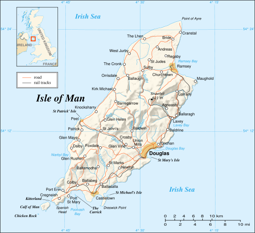
Map in English of the Isle of Man |
||||||
|---|---|---|---|---|---|---|---|
| Source |
Own work ; |
||||||
| Date |
May 2007 |
||||||
| Author |
Eric Gaba ( Sting) |
||||||
| Permission ( Reusing this image) |
GFDL or Creative Commons – Attribution – Share-Alike – 2.5 |
||||||
| Other versions |
|


- Sujet : Carte en anglais de l' Île de Man ;
- Sources : Création personnelle
-
- Fond de carte et relief ombré : NASA Shuttle Radar Topography Mission (SRTM3 v.2) (domaine public) édité avec 3DEM de Visualization Software LLC et vectorisé avec Inkscape ; projection UTM ; WGS84 datum ; relief ombré (image composite d'éclairages du N-O, O et N) ;
- Autres références utilisées pour les données complémentaires :
-
-
courriel d'approbation ainsi que le forum de Demis) ;
- NASA World Wind ;
- Carte de UK Genealogy ;
- Carte de localisation : Image:Gb4dot_merged_mapcolors.svg créée par Wereon et Ilmari Karonen dans le domaine public (modifiée) ;
- Échelle approximative : 1:372 000 (tracés des côtes / lacs) ;
- Note : Le relief ombré est une image bitmap encapsulée dans le fichier SVG qui augmente son poids. Si vous avez besoin d'une carte plus légère pour d'autres utilisations, supprimez l'image du relief ombré dans votre fichier ;
- Auteur : Eric Gaba ( fr:Sting) ;
- Date : Mai 2007 ;
- Autres versions : en français : Image:Isle_of_Man_map-fr.svg.
 |
This SVG file uses embedded text that can be easily translated into your language. Learn more. For SVG images, you can use this page to translate it into your language. العربية | Català | Dansk | Deutsch | English | Esperanto | Español | Français | Galego | Italiano | 日本語 | Lietuvių | Magyar | Nederlands | Polski | Português | Русский | Svenska | Українська | +/- |
Licensing
|

File history
Click on a date/time to view the file as it appeared at that time.
| Date/Time | Dimensions | User | Comment | |
|---|---|---|---|---|
| current | 23:03, 21 May 2007 | 1,200×1,100 (786 KB) | Sting | ({{Information |Description=Map in English of the Isle of Man |Source=Own work ;<br/>Background map and shaded relief : [http://www2.jpl.nasa.gov/srtm NASA Shuttle Radar Topography Mission] (SRTM3 v.2) (public domain) edited with [http:) |