Image:Ortelius - Maris Pacifici 1589.jpg

From Wikipedia, the free encyclopedia

Wikimedia Commons logo This is a file from the Wikimedia Commons. The description on its description page there is shown below.
Commons is a freely licensed media file repository. You can help.
Featured picture This is a featured picture on English Wikipedia and is considered one of the finest images.
  • If you think this file should be featured on Wikimedia Commons as well, feel free to nominate it.
  • If you have an image of similar quality that can be published under a suitable copyright license, be sure to upload it, tag it, and nominate it.
Wikimedia

Summary

Description

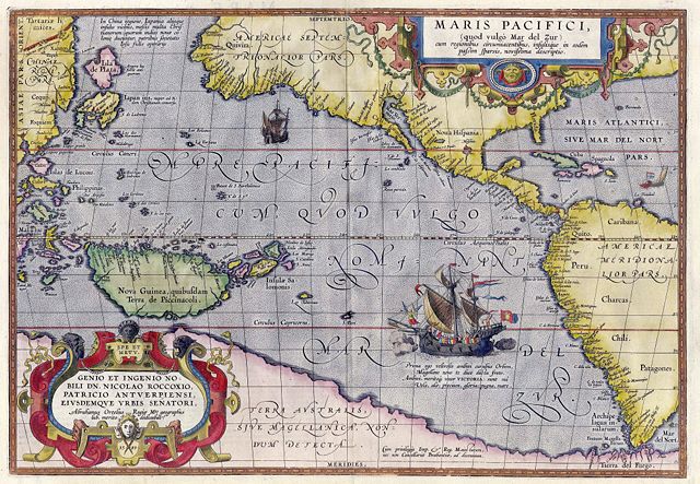
Maris Pacifici by Abraham Ortelius. This map was published in 1589 in his 'Theatrum Orbis Terrarum'. It was not only the first printed map of the Pacific, but it also showed for the first time the Americas as 'America Septentrionalior' and 'America Meridionalior'.(Ref: Koninklijke Belgische Bibliotheek)

Source

Helmink Antique Maps

Date

1589

Author

Abraham Ortelius

Permission
( Reusing this image)
This is a faithful photographic reproduction of an original two-dimensional work of art. The original image comprising the work of art itself is in the public domain for the following reason:
Public domain
This image (or other media file) is in the public domain because its copyright has expired.

This applies to the United States, Canada, the European Union and those countries with a copyright term of life of the author plus 70 years.


Note that a few countries have copyright terms longer than 70 years: Mexico has 100 years, Colombia has 80 years, and Guatemala and Samoa have 75 years. This image may not be in the public domain in these countries, which moreover do not implement the rule of the shorter term. Côte d'Ivoire has a general copyright term of 99 years and Honduras has 75 years, but they do implement that rule of the shorter term.


العربية | Asturianu | Български | Català | Česky | Dansk | Deutsch | English | Ελληνικά | Esperanto | Español | Euskara | فارسی | Français | Gaeilge | Galego | עברית | हिन्दी | Bahasa Indonesia | Italiano | 日本語 | 한국어 | Kurdî / كوردی | Lietuvių | Magyar | Nederlands | ‪Norsk (nynorsk)‬ | Македонски | Bahasa Melayu | Polski | Português | Română | Русский | Slovenčina | Slovenščina | Shqip | Suomi | Sámegiella | Türkçe | ‪中文(简体)‬ | ‪中文(繁體)‬ | 粵語 | +/-

Under United States copyright law, originality of expression is necessary for copyright protection, and a mere photograph of an out-of-copyright work may not be protected under U.S.copyright law. This photograph was taken in the U.S. or in another country where a similar rule applies (for a list of allowable countries, see Commons:When to use the PD-Art tag#Country-specific rules).
This photographic reproduction is therefore also in the public domain.

العربية | Česky | Deutsch | English | Ελληνικά | Español | فارسی | Français | עברית | Bahasa Indonesia | Italiano | 日本語 | 한국어 | Magyar | Nederlands | Polski | Português | Română | Русский | Slovenščina | Српски / Srpski | Basa Sunda | Türkçe | Українська | ‪中文(繁體)‬ | ‪中文(简体)‬ | +/-


File history

Click on a date/time to view the file as it appeared at that time.

Date/Time Dimensions User Comment
current 15:50, 5 May 2007 4,001×2,771 (3.81 MB) Jan Arkesteijn ({{Information |Description=Maris Pacifici by Abraham Ortelius |Source=[http://www.helmink.com/Antique_Map_Ortelius_Pacific/ Helmink Antique Maps] |Date=1589 |Author=Abraham Ortelius }} This map was published in 1589 in his 'Theatrum Orbis Terrarum'. It w)
The following pages on Schools Wikipedia link to this image (list may be incomplete):

Metadata

This file contains additional information, probably added from the digital camera or scanner used to create or digitize it. If the file has been modified from its original state, some details may not fully reflect the modified file.

This Wikipedia Selection has a sponsor: SOS Children , and is mainly selected from the English Wikipedia with only minor checks and changes (see www.wikipedia.org for details of authors and sources). See also our Disclaimer.