Image:Usgs map stereographic.PNG
From Wikipedia, the free encyclopedia
No higher resolution available.
Usgs_map_stereographic.PNG (534 × 181 pixels, file size: 49 KB, MIME type: image/png)
| |
This is a file from the Wikimedia Commons. The description on its description page there is shown below. |
-
- (see below: Enlarged view)
Summary
| Description |
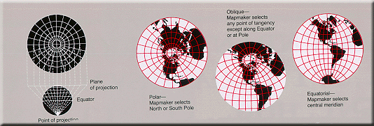
Condensed explanation of stereographic projection maps, colored as smaller PNG image, from larger, wider USGS file of GIF format. See enlarged view below, using a wikitable to expand beyond original size. |
|---|---|
| Source |
derivative from USGS image file (with map sections colored red/white),
|
| Date |
17-February-2005 |
| Author |
User:Quadell, re-coloring US Government USGS image. |
| Permission ( Reusing this image) |
(see below) |
| Other versions |
Taller arrangement of globes with enlarged lettering/clarified, up to 3x faster (GIF format): |
Enlarged view
| Explanation of stereographic projection. |
Licensing
 |
I, the copyright holder of this work, hereby release it into the public domain. This applies worldwide. In case this is not legally possible: Afrikaans | Alemannisch | Aragonés | العربية | Asturianu | Български | Català | Cebuano | Česky | Cymraeg | Dansk | Deutsch | Eʋegbe | Ελληνικά | English | Español | Esperanto | Euskara | Estremeñu | فارسی | Français | Galego | 한국어 | हिन्दी | Hrvatski | Ido | Bahasa Indonesia | Íslenska | Italiano | עברית | Kurdî / كوردی | Latina | Lietuvių | Latviešu | Magyar | Македонски | Bahasa Melayu | Nederlands | Norsk (bokmål) | Norsk (nynorsk) | 日本語 | Polski | Português | Ripoarisch | Română | Русский | Shqip | Slovenčina | Slovenščina | Српски / Srpski | Suomi | Svenska | ไทย | Tagalog | Türkçe | Українська | Tiếng Việt | Walon | 中文(简体) | 中文(繁體) | zh-yue-hant | +/- |
| |
This image is in the public domain because it contains materials that originally came from the United States Geological Survey, an agency of the United States Department of Interior. For more information, see the official USGS copyright policy |
|
 |
This map image should be recreated using vector graphics as an SVG file. This has several advantages; see Commons:Media for cleanup for more information. If an SVG form of this image is already available, please upload it. After uploading an SVG, replace this template with {{ vector version available|new image name.svg}}. |
|
العربية | Български | Català | Česky | Dansk | Deutsch | English | Esperanto | Español | Français | Galego | 한국어 | Italiano | Magyar | Lietuvių | Nederlands | 日本語 | Polski | Português | Română | Русский | Suomi | Svenska | Türkçe | Українська | 中文(繁體) | 中文(简体) | +/- |
|
File history
Click on a date/time to view the file as it appeared at that time.
| Date/Time | Dimensions | User | Comment | |
|---|---|---|---|---|
| current | 14:27, 17 February 2005 | 534×181 (49 KB) | Quadell | (World map projection ([http://erg.usgs.gov/isb/pubs/MapProjections/projections.html source)]{{PD-USGov-USGS}} Category:World maps Category:Map projections Category:Map diagrams) |