Image:WhereRainbowRises.jpg
From Wikipedia, the free encyclopedia
Size of this preview: 318 × 479 pixels
Full resolution (1,360 × 2,048 pixels, file size: 3.6 MB, MIME type: image/jpeg)
| |
This is a file from the Wikimedia Commons. The description on its description page there is shown below. |
| This is a featured picture, which means that members of the community have identified it as one of the finest images on the English Wikipedia, adding significantly to its accompanying article. If you have a different image of similar quality, be sure to upload it using the proper free license tag, add it to a relevant article, and nominate it. |
| |
This image was selected as picture of the day on the English Wikipedia for May 28, 2006. |
| |
This is a featured picture on English Wikipedia and is considered one of the finest images.
|
|
| Description |
Česky: Duha
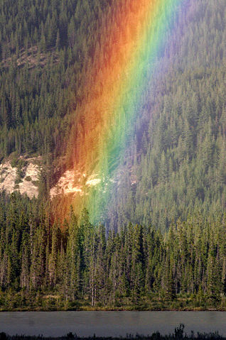
English: This photo shows the place where the rainbow rises (the end of a rainbow), many mythologies were associated with such places.
中文: 彩虹升起之地,彩虹的盡頭
|
|||
|---|---|---|---|---|
| Source |
self-made; at Jasper National Park, Alberta, Canada (along Yellowhead Highway 16 between intersection to Malign Valley Road and intersection to Snaring River Campground, overlooking Colin Range in the south). |
|||
| Date |
1st July 2005 |
|||
| Author |
Wing-Chi Poon |
|||
| Permission ( Reusing this image) |
|
|||
| Other versions |   |
| Camera location |
|
See this image at its location on Google Maps This location on: Live Maps - Trails.com - TerraServer-USA |
|---|
Awards
| |
This image was selected as a picture of the day for December 11, 2005. It was captioned as followed: English: Where rainbow rises
Asturianu: Arcu la vieya
Česky: Tam, kde začíná duha
Deutsch: Regenbogen über einem Nadelwald in Kanada.
English: Where rainbow rises
Français : Bout d'arc-en-ciel
Magyar: A szivárvány töve.
Italiano: Dove sorge l' arcobaleno
日本語: 虹
Nederlands: Het einde van de Regenboog.
Polski: Gdzie zaczyna się tęcza
Русский: Где начинается радуга
Slovenščina: Kjer se začenja mavrica
Svenska: Regnbågens slut
中文(简体): 彩虹升起的地方
|
| |
This image was selected as a picture of week on the Czech Wikipedia for 3rd week, 2008. Tento obrázek byl vybrán jako obrázek týdne na České Wikipedii pro 3. týden, 2008. |
|
File history
Click on a date/time to view the file as it appeared at that time.
| Date/Time | Dimensions | User | Comment | |
|---|---|---|---|---|
| current | 04:38, 8 August 2006 | 1,360×2,048 (3.6 MB) | Majestic | (levels modified; same license) |
| 18:15, 7 November 2005 | 1,360×2,048 (1.65 MB) | Wingchi | (Taken by Wing-Chi Poon on 1st July 2005 in Jasper National Park, Alberta, Canada (along Yellowhead Highway 16 between intersection to Malign Valley Road and intersection to Snaring River Campground, overlooking Colin Range in the south). This photo shows ) |
File links
The following pages on Schools Wikipedia link to this image (list may be incomplete):
Metadata
This file contains additional information, probably added from the digital camera or scanner used to create or digitize it. If the file has been modified from its original state, some details may not fully reflect the modified file.
| Camera manufacturer | Canon |
|---|---|
| Camera model | Canon EOS DIGITAL REBEL |
| Exposure time | 1/800 sec (0.00125) |
| F-number | f/10 |
| Date and time of data generation | 22:01, 1 July 2005 |
| Lens focal length | 160 mm |
| Orientation | Normal |
| Horizontal resolution | 180 dpi |
| Vertical resolution | 180 dpi |
| Software used | Adobe Photoshop CS2 Windows |
| File change date and time | 07:37, 8 August 2006 |
| Y and C positioning | 1 |
| ISO speed rating | 800 |
| Exif version | 2.2 |
| Date and time of digitizing | 22:01, 1 July 2005 |
| Shutter speed | 9.64385986328 |
| Aperture | 6.64385986328 |
| Exposure bias | 0 |
| Flash | 0 |
| Colour space | sRGB |
| Focal plane X resolution | 2285.71428571 |
| Focal plane Y resolution | 2295.96412556 |
| Focal plane resolution unit | inches |
| Custom image processing | Normal process |
| Exposure mode | Auto exposure |
| White balance | Auto white balance |
| Scene capture type | Standard |
Categories: Wikipedia featured pictures